IMAGES TAKEN NEAR TO
St. Davids Close, WEMBLEY, HA9 9RL
Introduction
This page details the photographs taken nearby to St. Davids Close, HA9 9RL by members of the Geograph project.
The Geograph project started in 2005 with the aim of publishing, organising and preserving representative images for every square kilometre of Great Britain, Ireland and the Isle of Man.

There are currently over 7.5m images from over14,400 individuals and you can help contribute to the project by visiting https://www.geograph.org.uk
Image Map
Images are licensed for reuse under creativecommons.org/licenses/by-sa/2.0
Notes
- Clicking on the map will re-center to the selected point.
- The higher the marker number, the further away the image location is from the centre of the postcode.
Image Listing (35 Images Found)
Images are licensed for reuse under creativecommons.org/licenses/by-sa/2.0
Image
Details
Distance
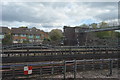
1
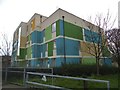
Flats on St Davids Close, Wembley Park
Image: © David Howard
Taken: 10 Apr 2018
0.03 miles
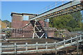
2
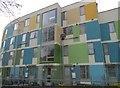
Flats on St Davids Close, Wembley Park
Image: © David Howard
Taken: 10 Apr 2018
0.04 miles

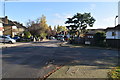
4
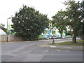
Flats on St Davids Close, Wembley Park
You can see the general design between the trees, which is quite imaginative.
Image: © David Howard
Taken: 31 Jul 2014
0.05 miles
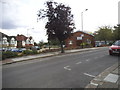
5

Church of Christ Meeting Place, Wembley Park
Image: © David Howard
Taken: 10 Apr 2018
0.05 miles
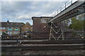
10
Church of Christ Meeting Point, Barnhill Road
Image: © David Howard
Taken: 31 Jul 2014
0.07 miles