IMAGES TAKEN NEAR TO
Beverley Gardens, WEMBLEY, HA9 9RB
Introduction
This page details the photographs taken nearby to Beverley Gardens, HA9 9RB by members of the Geograph project.
The Geograph project started in 2005 with the aim of publishing, organising and preserving representative images for every square kilometre of Great Britain, Ireland and the Isle of Man.

There are currently over 7.5m images from over14,400 individuals and you can help contribute to the project by visiting https://www.geograph.org.uk
Image Map
Images are licensed for reuse under creativecommons.org/licenses/by-sa/2.0
Notes
- Clicking on the map will re-center to the selected point.
- The higher the marker number, the further away the image location is from the centre of the postcode.
Image Listing (66 Images Found)
Images are licensed for reuse under creativecommons.org/licenses/by-sa/2.0
Image
Details
Distance
3
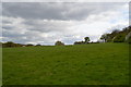
Roundabout on Beverley Gardens
Junction with West Hill, Wembley Park
Image: © David Howard
Taken: 15 Dec 2010
0.14 miles
6
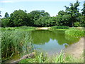
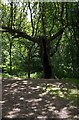
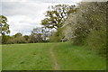
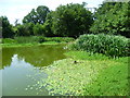
The fishpond on Barn Hill
Barn Hill is part of Fryent Country Park. The Country Park has been kept to show how much of Middlesex looked before the suburban expansion of London in the 1920s and 1930s. There are 23 hay meadows and seven miles of hedgerows, four woods and 20 ponds.
Much of the woodland on Barn Hill was planted by the landscape architect Humphry Repton in about 1793 for the then landowner, Richard Page, who also owned Wembley Park. The fishpond was another of Repton's features. It is close to the Trig Point on Barn Hill and the Capital Ring also passes it.
Image: © Marathon
Taken: 1 Jul 2015
0.17 miles
7
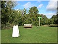
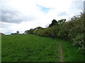
Sign, Seat & Trig Point
The top of Barn Hill in Fryent Country Park.
Good views to the south.
On the Capital Ring path, which is what the green sign is about.
86 metres aod.
Image: © Des Blenkinsopp
Taken: 16 Oct 2014
0.17 miles
9
The fishpond on Barn Hill
Barn Hill is part of Fryent Country Park. The Country Park has been kept to show how much of Middlesex looked before the suburban expansion of London in the 1920s and 1930s. There are 23 hay meadows and seven miles of hedgerows, four woods and 20 ponds.
Much of the woodland on Barn Hill was planted by the landscape architect Humphry Repton in about 1793 for the then landowner, Richard Page, who also owned Wembley Park. The fishpond was another of Repton's features. It is close to the Trig Point on Barn Hill and the Capital Ring also passes it.
Image: © Marathon
Taken: 1 Jul 2015
0.17 miles
10
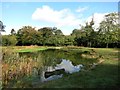
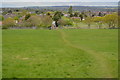
Pond on top of Barn Hill
An ornamental pond created as part of the landscaping when Fryent Park was a country estate.
It is beside the Capital Ring path.
Image: © Des Blenkinsopp
Taken: 16 Oct 2014
0.17 miles