IMAGES TAKEN NEAR TO
Barn Rise, WEMBLEY, HA9 9NF
Introduction
This page details the photographs taken nearby to Barn Rise, HA9 9NF by members of the Geograph project.
The Geograph project started in 2005 with the aim of publishing, organising and preserving representative images for every square kilometre of Great Britain, Ireland and the Isle of Man.

There are currently over 7.5m images from over14,400 individuals and you can help contribute to the project by visiting https://www.geograph.org.uk
Image Map
Images are licensed for reuse under creativecommons.org/licenses/by-sa/2.0
Notes
- Clicking on the map will re-center to the selected point.
- The higher the marker number, the further away the image location is from the centre of the postcode.
Image Listing (61 Images Found)
Images are licensed for reuse under creativecommons.org/licenses/by-sa/2.0
Image
Details
Distance
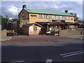
2
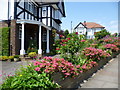
Barn Hill, Wembley
This colourful front garden is just up the road called Barn Hill which leads up to Barn Hill itself, part of Fryent Country Park. The house beyond is in Grendon Gardens.
Image: © Marathon
Taken: 1 Jul 2015
0.10 miles
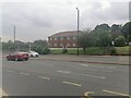
7
Forty Lane at the junction of Bridge Road
Image: © David Howard
Taken: 17 Jun 2019
0.15 miles
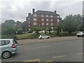
9
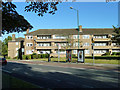
Flats, Newland Court
One of five blocks of flats arranged zig-zag fashion.
Image: © Robin Webster
Taken: 29 Sep 2012
0.15 miles
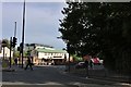
10
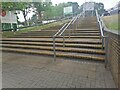
Stairs from Asda to Forty Lane, Wembley Park
Image: © David Howard
Taken: 17 Jun 2021
0.16 miles