IMAGES TAKEN NEAR TO
Matthews Close, WEMBLEY, HA9 8FG
Introduction
This page details the photographs taken nearby to Matthews Close, HA9 8FG by members of the Geograph project.
The Geograph project started in 2005 with the aim of publishing, organising and preserving representative images for every square kilometre of Great Britain, Ireland and the Isle of Man.

There are currently over 7.5m images from over14,400 individuals and you can help contribute to the project by visiting https://www.geograph.org.uk
Image Map
Images are licensed for reuse under creativecommons.org/licenses/by-sa/2.0
Notes
- Clicking on the map will re-center to the selected point.
- The higher the marker number, the further away the image location is from the centre of the postcode.
Image Listing (162 Images Found)
Images are licensed for reuse under creativecommons.org/licenses/by-sa/2.0
Image
Details
Distance
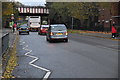
8
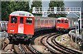
Wembley Park
Trains arriving at Wembley Park Tube Station.
Image: © Peter McDermott
Taken: 1 Sep 2011
0.07 miles
10
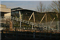
Wembley: the Sattavis Patidar Centre, Forty Avenue, from the MetropolitanLine
Image: © Christopher Hilton
Taken: 20 Jan 2015
0.07 miles