IMAGES TAKEN NEAR TO
Manor Drive, WEMBLEY, HA9 8EF
Introduction
This page details the photographs taken nearby to Manor Drive, HA9 8EF by members of the Geograph project.
The Geograph project started in 2005 with the aim of publishing, organising and preserving representative images for every square kilometre of Great Britain, Ireland and the Isle of Man.

There are currently over 7.5m images from over14,400 individuals and you can help contribute to the project by visiting https://www.geograph.org.uk
Image Map
Images are licensed for reuse under creativecommons.org/licenses/by-sa/2.0
Notes
- Clicking on the map will re-center to the selected point.
- The higher the marker number, the further away the image location is from the centre of the postcode.
Image Listing (107 Images Found)
Images are licensed for reuse under creativecommons.org/licenses/by-sa/2.0
Image
Details
Distance
1
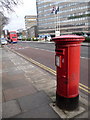
Wembley: postbox № HA9 135, Empire Way
A large, Elizabeth II-reign postbox standing with its back to a view across Empire Way to Wembley Station. The box is emptied finally at 5pm on weekdays and at 12:45pm on Saturdays.
One of the several hotels in this area is in the background.
Image: © Chris Downer
Taken: 10 Jan 2011
0.08 miles
2
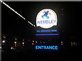
Sign at the entrance to Wembley International Hotel
Image: © David Howard
Taken: 21 Dec 2017
0.09 miles
3

Student accommodation on Empire Way, Wembley
Image: © David Howard
Taken: 21 Dec 2017
0.09 miles
4

The Quality Hotel Wembley on Empire Way
Image: © David Howard
Taken: 8 Jul 2013
0.10 miles
5
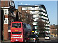
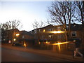
Wembley: bus on Wembley Hill Road
Beyond the bus, we see Image
Image: © Chris Downer
Taken: 9 Jan 2011
0.10 miles


10
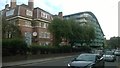
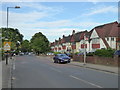
Flats on Empire Way, Wembley
Most of the flats along the west side of Empire Way are of a similar inter-war vintage: the modern block inserted into them replaces a similar inter-war block demolished, according to Google Streetview, between August 2008 and October 2009.
Image: © Christopher Hilton
Taken: 31 Aug 2016
0.11 miles