IMAGES TAKEN NEAR TO
Castleton Avenue, WEMBLEY, HA9 7QL
Introduction
This page details the photographs taken nearby to Castleton Avenue, HA9 7QL by members of the Geograph project.
The Geograph project started in 2005 with the aim of publishing, organising and preserving representative images for every square kilometre of Great Britain, Ireland and the Isle of Man.

There are currently over 7.5m images from over14,400 individuals and you can help contribute to the project by visiting https://www.geograph.org.uk
Image Map
Images are licensed for reuse under creativecommons.org/licenses/by-sa/2.0
Notes
- Clicking on the map will re-center to the selected point.
- The higher the marker number, the further away the image location is from the centre of the postcode.
Image Listing (17 Images Found)
Images are licensed for reuse under creativecommons.org/licenses/by-sa/2.0
Image
Details
Distance
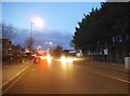
1
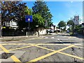
Castleton Avenue at the junction of East Lane
Image: © David Howard
Taken: 23 Aug 2023
0.07 miles
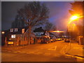
2
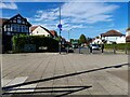
St Augustine's Avenue, Wembley
From East Lane
Image: © David Howard
Taken: 23 Aug 2023
0.09 miles
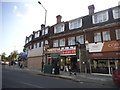
6
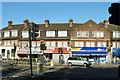
Corner shops
The pediment tells that the parade was built in 1927.
Image: © Robin Webster
Taken: 29 Sep 2012
0.21 miles
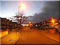
7
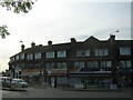
Parade of shops at East Lane / Preston Road junction
Image: © Christopher Hilton
Taken: 2 Sep 2016
0.21 miles
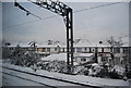
10
Beechcroft Gardens at the junction of Wembley Hill Road
Image: © David Howard
Taken: 5 Feb 2015
0.22 miles