IMAGES TAKEN NEAR TO
Wembley Commercial Centre, East Lane, WEMBLEY, HA9 7NL
Introduction
This page details the photographs taken nearby to Wembley Commercial Centre, East Lane, HA9 7NL by members of the Geograph project.
The Geograph project started in 2005 with the aim of publishing, organising and preserving representative images for every square kilometre of Great Britain, Ireland and the Isle of Man.

There are currently over 7.5m images from over14,400 individuals and you can help contribute to the project by visiting https://www.geograph.org.uk
Image Map (Loading...)


Getting Data...Please wait
Leaflet Map data © OpenStreetMap
Images are licensed for reuse under creativecommons.org/licenses/by-sa/2.0
Notes
- Clicking on the map will re-center to the selected point.
- The higher the marker number, the further away the image location is from the centre of the postcode.
Image Listing (54 Images Found)
Images are licensed for reuse under creativecommons.org/licenses/by-sa/2.0
Image
Details
Distance
3
North Wembley: Passage leading north from Byron Road
This pedestrian way gives access into Nathans Road
Image: © Dr Neil Clifton
Taken: 1 Jun 2011
0.07 miles
4
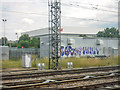
London Borough of Brent : West Coast Main Line
Looking across and along the West Coast Main Line from the Bakerloo Line.
Image: © Lewis Clarke
Taken: 18 Jul 2019
0.10 miles
5
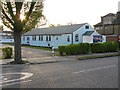
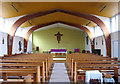
The Annunciation, Windermere Avenue, London HA3 - West end
Image: © John Salmon
Taken: 16 Feb 2005
0.10 miles
6
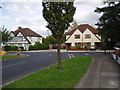
New houses, Nathans Road, North Wembley, Middlesex
When the Sudbury Court estate was laid out in the early 1930's, it was intended that Carlton Avenue West (where the photographer is standing) should be connected to Carlton Avenue East by a bridge over the LMS railway. Accordingly a gap was left in the houses along Nathans Road to allow for the bridge. But before the bridge could be constructed, World War II intervened, and after the war, the site remained vacant and the idea of the bridge was abandoned. Recently, however, two new semi-detached houses (right) were erected to fill the gap - in the same style as those built some 70 years earlier (seen to the left)
Image: © Dr Neil Clifton
Taken: 3 Oct 2005
0.11 miles
7
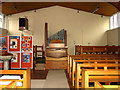
Tin Church, Windermere Avenue, London HA9
Image: © John Salmon
Taken: 16 Nov 2004
0.11 miles
8
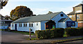
Church of the Annunciation, Windermere Avenue, South Kenton
Image: © Peter Whatley
Taken: 10 Apr 2011
0.11 miles
9
The Annunciation, Windermere Avenue, London HA3 - East end
Image: © John Salmon
Taken: 16 Feb 2005
0.11 miles
10

Tin Church, Windermere Avenue, London HA3 - Notice board
Image: © John Salmon
Taken: 16 Nov 2004
0.11 miles