IMAGES TAKEN NEAR TO
The Glen, WEMBLEY, HA9 7LA
Introduction
This page details the photographs taken nearby to The Glen, HA9 7LA by members of the Geograph project.
The Geograph project started in 2005 with the aim of publishing, organising and preserving representative images for every square kilometre of Great Britain, Ireland and the Isle of Man.

There are currently over 7.5m images from over14,400 individuals and you can help contribute to the project by visiting https://www.geograph.org.uk
Image Map
Images are licensed for reuse under creativecommons.org/licenses/by-sa/2.0
Notes
- Clicking on the map will re-center to the selected point.
- The higher the marker number, the further away the image location is from the centre of the postcode.
Image Listing (20 Images Found)
Images are licensed for reuse under creativecommons.org/licenses/by-sa/2.0
Image
Details
Distance
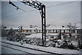
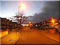
2
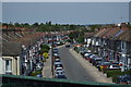
Houses on Llanover Road
From the railway.
Image: © Andrew Abbott
Taken: 5 Jun 2019
0.08 miles
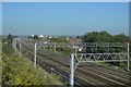
3
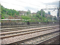
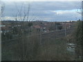
London Borough of Brent : West Coast Main Line
Looking along the tracks of the West Coast Main Line.
Image: © Lewis Clarke
Taken: 18 Jul 2019
0.16 miles
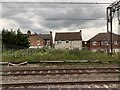
4
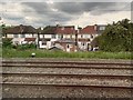
St John's Road, Wembley
The backs of houses on St John's Road, Wembley, taken from the railway.
Image: © Andrew Abbott
Taken: 5 Jun 2019
0.16 miles
5
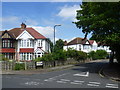
St John's Road, Wembley
St John's Road is seen here at the junction with Keswick Gardens.
Image: © Marathon
Taken: 15 Jul 2015
0.17 miles
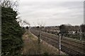
8
WCML looking north from a Chiltern Line train
Image: © Colin Pyle
Taken: 28 Feb 2016
0.22 miles