1
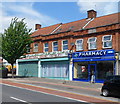
A pharmacy and a cultural centre, Tokyngton
Monks Chem Ltd pharmacy is at 70 Harrow Road. Next door, the Islamic Cultural Centre (Wembley) is
at the NW end of a long row of shops. Beyond are houses.
Image: © Jaggery
Taken: 13 May 2012
0.08 miles
2
Harrow Road, A404, with a row of shops
Image: © David Smith
Taken: 23 Nov 2017
0.09 miles
3
Harrow Road shops north of Monks Park, Tokyngton
Tokyngton, part of the London Borough of Brent and Wembley postal area,
is located south of the suburb of Wembley.
Image: © Jaggery
Taken: 13 May 2012
0.09 miles
4
Junction of Harrow Road, A404, with Victoria Avenue
The Wembley Arch is visible in the gap between buildings
Image: © David Smith
Taken: 23 Nov 2017
0.11 miles
5
Brent River Park
This is actually a wildflower meadow, created in recompense for a small loss of parkland when the North Circular Road was widened in the 1990s. The land was re-contoured and the area was seeded with a wildflower mix.
Image: © Marathon
Taken: 22 Oct 2014
0.12 miles
6
Sculpture in Brent River Park
This is actually a wildflower meadow, created in recompense for a small loss of parkland when the North Circular Road was widened in the 1990s. The land was re-contoured and the area was seeded with a wildflower mix.
Image: © Marathon
Taken: 22 Oct 2014
0.13 miles
7
Harrow Road heading north
Image: © Steve Daniels
Taken: 13 Jul 2020
0.15 miles
8
The Innisfree, Tokyngton
Pub at 30-32 Harrow Road.
On researching this location, I noticed that, while still in London, I had left NW10 and the London postal district and entered (in postal terms) the Harrow district. The creation of Greater London in 1965 extended the boundary of London far beyond the London postal district, which was not expanded in step. The changes needed would have been too costly.
Image: © Jaggery
Taken: 13 May 2012
0.16 miles
9
Houses in Vivian Avenue, seen from Victoria Avenue
Image: © David Smith
Taken: 23 Nov 2017
0.16 miles
10
Harrow Road, Stonebridge Park
Image: © Stacey Harris
Taken: 12 Feb 2011
0.17 miles


