IMAGES TAKEN NEAR TO
Aldbury Avenue, WEMBLEY, HA9 6EX
Introduction
This page details the photographs taken nearby to Aldbury Avenue, HA9 6EX by members of the Geograph project.
The Geograph project started in 2005 with the aim of publishing, organising and preserving representative images for every square kilometre of Great Britain, Ireland and the Isle of Man.

There are currently over 7.5m images from over14,400 individuals and you can help contribute to the project by visiting https://www.geograph.org.uk
Image Map (Loading...)


Getting Data...Please wait
Leaflet Map data © OpenStreetMap
Images are licensed for reuse under creativecommons.org/licenses/by-sa/2.0
Notes
- Clicking on the map will re-center to the selected point.
- The higher the marker number, the further away the image location is from the centre of the postcode.
Image Listing (93 Images Found)
Images are licensed for reuse under creativecommons.org/licenses/by-sa/2.0
Image
Details
Distance
2
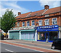
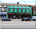
A pharmacy and a cultural centre, Tokyngton
Monks Chem Ltd pharmacy is at 70 Harrow Road. Next door, the Islamic Cultural Centre (Wembley) is
at the NW end of a long row of shops. Beyond are houses.
Image: © Jaggery
Taken: 13 May 2012
0.05 miles
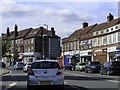
3
Harrow Road shops north of Monks Park, Tokyngton
Tokyngton, part of the London Borough of Brent and Wembley postal area,
is located south of the suburb of Wembley.
Image: © Jaggery
Taken: 13 May 2012
0.07 miles
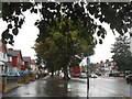
4
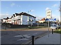
Junction of Harrow Road, A404, with Victoria Avenue
The Wembley Arch is visible in the gap between buildings
Image: © David Smith
Taken: 23 Nov 2017
0.09 miles
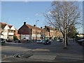
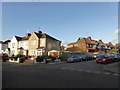
5
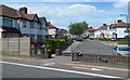
Junction of Aldbury Avenue and Tokyngton Avenue
Image: © David Smith
Taken: 23 Nov 2017
0.12 miles
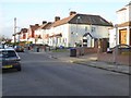
7
Junction of Sylvia Gardens and Tokyngton Avenue
An area of suburban housing
Image: © David Smith
Taken: 23 Nov 2017
0.12 miles
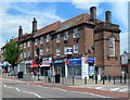
9
The Innisfree, Tokyngton
Pub at 30-32 Harrow Road.
On researching this location, I noticed that, while still in London, I had left NW10 and the London postal district and entered (in postal terms) the Harrow district. The creation of Greater London in 1965 extended the boundary of London far beyond the London postal district, which was not expanded in step. The changes needed would have been too costly.
Image: © Jaggery
Taken: 13 May 2012
0.13 miles
10
Tokyngton Avenue, Tokyngton
The SE end of Tokyngton Avenue is at railings alongside Point Place.
Image: © Jaggery
Taken: 13 May 2012
0.13 miles