IMAGES TAKEN NEAR TO
Handel Way, EDGWARE, HA8 6LG
Introduction
This page details the photographs taken nearby to Handel Way, HA8 6LG by members of the Geograph project.
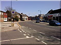
The Geograph project started in 2005 with the aim of publishing, organising and preserving representative images for every square kilometre of Great Britain, Ireland and the Isle of Man.

There are currently over 7.5m images from over14,400 individuals and you can help contribute to the project by visiting https://www.geograph.org.uk
Image Map
Images are licensed for reuse under creativecommons.org/licenses/by-sa/2.0
Notes
- Clicking on the map will re-center to the selected point.
- The higher the marker number, the further away the image location is from the centre of the postcode.
Image Listing (131 Images Found)
Images are licensed for reuse under creativecommons.org/licenses/by-sa/2.0
Image
Details
Distance
1
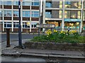
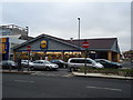
Office blocks by Chandos Recreation Ground, Edgware
Image: © David Howard
Taken: 24 Jan 2014
0.06 miles
2
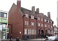
Edgware Police Station, Whitchurch Lane
Image: © Robin Sones
Taken: 17 Sep 2014
0.07 miles
3
Hair Roxx, Whitchurch Lane
At the junction with Buckingham Road
Image: © Robin Sones
Taken: 17 Sep 2014
0.07 miles
4
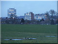
Whitchurch Lane, Edgware
Heading east towards the town centre.
Image: © Jim Smillie
Taken: 21 Apr 2010
0.07 miles
5
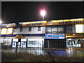
Safestore on Edgware High Street
Due to the smaller rooms in new houses many people are having to put more of their belongings in storage so these warehouses are being opened all over London.
Image: © David Howard
Taken: 28 Feb 2017
0.09 miles
6
Edgware: Whitchurch Lane
Police station on the south side of road.
Image: © Jim Smillie
Taken: 21 Apr 2010
0.09 miles
7
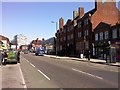
Edgware High Street
If you turn the other way you can drive all the way to Holyhead on the one road. This direction goes to Marble Arch.
Image: © David Howard
Taken: 9 Jan 2015
0.09 miles
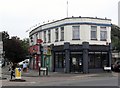
9
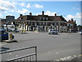
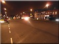
Edgware: The Masons Arms
Located on the A5 High Street in Edgware this is another 1930s road pub. This one is owned by the Ribo Waring Pub Company and its website is here http://www.masonsarmspub.moonfruit.com/#
The A5 crosses from far left to near right here and follows the route of the old Roman Road of Watling Street. It also forms the boundary between the London Boroughs of Harrow (the pub and the far side of the road) and Barnet (the photographer's and the near side of the road).
Image: © Nigel Cox
Taken: 25 Jul 2009
0.10 miles