IMAGES TAKEN NEAR TO
Scott Road, EDGWARE, HA8 5QR
Introduction
This page details the photographs taken nearby to Scott Road, HA8 5QR by members of the Geograph project.
The Geograph project started in 2005 with the aim of publishing, organising and preserving representative images for every square kilometre of Great Britain, Ireland and the Isle of Man.

There are currently over 7.5m images from over14,400 individuals and you can help contribute to the project by visiting https://www.geograph.org.uk
Image Map
Images are licensed for reuse under creativecommons.org/licenses/by-sa/2.0
Notes
- Clicking on the map will re-center to the selected point.
- The higher the marker number, the further away the image location is from the centre of the postcode.
Image Listing (35 Images Found)
Images are licensed for reuse under creativecommons.org/licenses/by-sa/2.0
Image
Details
Distance
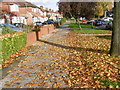
3
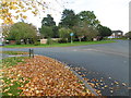
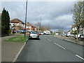
Autumn leaves along Beverley Drive
The name of Queensbury was the winner of a competition run by a Golders Green estate agent (Percy H Edwards) to come up with a title for the new district to the north of Kingsbury. Traffic on the railway grew only slowly, possibly because the Metropolitan charged main line fares. People found it cheaper to go to Edgware by bus and take the Hampstead Tube. Queensbury was the most rapidly- developed estate in north-west London. The landscape was largely flat and devoid of natural features.
For more about the station see http://www.geograph.org.uk/photo/4719174
Late October sees the leaves piled up on the pavement of Beverley Drive in Queensbury.
Image: © Marathon
Taken: 28 Oct 2015
0.15 miles
5
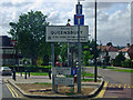
Welcome to Queensbury
Queensbury was originally Little Stanmore, but with the arrival of the railway a new name was needed to avoid confusion with Stanmore, and a competition was held. The winner simply used the alternative to the adjacent Kingsbury and there it was. It is divided between Brent and Harrow boroughs which make half a suburb of Edgware (HA8) and half Stanmore (HA7).
Image: © David Howard
Taken: 16 May 2009
0.16 miles
9
Autumn leaves along Beverley Drive
The name of Queensbury was the winner of a competition run by a Golders Green estate agent (Percy H Edwards) to come up with a title for the new district to the north of Kingsbury. Traffic on the railway grew only slowly, possibly because the Metropolitan charged main line fares. People found it cheaper to go to Edgware by bus and take the Hampstead Tube. Queensbury was the most rapidly- developed estate in north-west London. The landscape was largely flat and devoid of natural features.
For more about the station see http://www.geograph.org.uk/photo/4719174
The late October sun catches the leaves along the pavement of Beverley Drive in Queensbury.
Image: © Marathon
Taken: 28 Oct 2015
0.19 miles
10
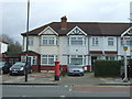
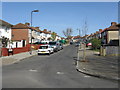
Houses on Stag Lane, Edgware
Showing position of Postbox No. HA8 740.
See Image] for postbox.
Image: © JThomas
Taken: 18 Mar 2017
0.19 miles