IMAGES TAKEN NEAR TO
Croxden Close, EDGWARE, HA8 5PS
Introduction
This page details the photographs taken nearby to Croxden Close, HA8 5PS by members of the Geograph project.
The Geograph project started in 2005 with the aim of publishing, organising and preserving representative images for every square kilometre of Great Britain, Ireland and the Isle of Man.

There are currently over 7.5m images from over14,400 individuals and you can help contribute to the project by visiting https://www.geograph.org.uk
Image Map
Images are licensed for reuse under creativecommons.org/licenses/by-sa/2.0
Notes
- Clicking on the map will re-center to the selected point.
- The higher the marker number, the further away the image location is from the centre of the postcode.
Image Listing (69 Images Found)
Images are licensed for reuse under creativecommons.org/licenses/by-sa/2.0
Image
Details
Distance
1
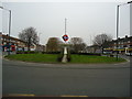
Queensbury - Calder Gardens from Beverley Drive
Image: © Peter Whatley
Taken: 1 Apr 2012
0.02 miles
2
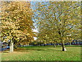
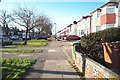
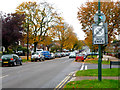
A green at Queensbury
The name of Queensbury was the winner of a competition run by a Golders Green estate agent (Percy H Edwards) to come up with a title for the new district to the north of Kingsbury. Traffic on the railway grew only slowly, possibly because the Metropolitan charged main line fares. People found it cheaper to go to Edgware by bus and take the Hampstead Tube. Queensbury was the most rapidly- developed estate in north-west London. The landscape was largely flat and devoid of natural features.
This attractive green is just east of Queensbury Underground station and the surrounding road is Beverley Drive. For more about the station see http://www.geograph.org.uk/photo/4719174
Image: © Marathon
Taken: 28 Oct 2015
0.08 miles
4
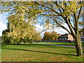
Green at Queensbury
The name of Queensbury was the winner of a competition run by a Golders Green estate agent (Percy H Edwards) to come up with a title for the new district to the north of Kingsbury. Traffic on the railway grew only slowly, possibly because the Metropolitan charged main line fares. People found it cheaper to go to Edgware by bus and take the Hampstead Tube. Queensbury was the most rapidly- developed estate in north-west London. The landscape was largely flat and devoid of natural features.
This attractive green is just east of Queensbury Underground station and the surrounding road is Beverley Drive. For more about the station see http://www.geograph.org.uk/photo/4719174
Image: © Marathon
Taken: 28 Oct 2015
0.09 miles
7
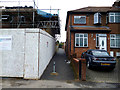
Queensbury: Mollison Way: Foot passage leading to Tiverton Road
Not suitable for cars, as can be seen. The house on the right is No 194, Mollison Drive. Next door, No 196 is undergoing extensive rebuilding.
Image: © Dr Neil Clifton
Taken: 30 Oct 2015
0.11 miles
8
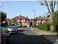
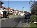
Edgware: Mollison Way
Viewed looking westwards along the north side of the road from the Waltham Drive roundabout.
Image: © Nigel Cox
Taken: 17 Dec 2005
0.11 miles
10
Queensbury: Beverley Drive
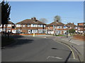
Looking east, from the end of Sandhurst Road.
Image: © Dr Neil Clifton
Taken: 30 Oct 2015
0.11 miles