IMAGES TAKEN NEAR TO
Holmstall Parade, Burnt Oak Broadway, EDGWARE, HA8 5HX
Introduction
This page details the photographs taken nearby to Holmstall Parade, Burnt Oak Broadway, HA8 5HX by members of the Geograph project.
The Geograph project started in 2005 with the aim of publishing, organising and preserving representative images for every square kilometre of Great Britain, Ireland and the Isle of Man.

There are currently over 7.5m images from over14,400 individuals and you can help contribute to the project by visiting https://www.geograph.org.uk
Image Map
Images are licensed for reuse under creativecommons.org/licenses/by-sa/2.0
Notes
- Clicking on the map will re-center to the selected point.
- The higher the marker number, the further away the image location is from the centre of the postcode.
Image Listing (37 Images Found)
Images are licensed for reuse under creativecommons.org/licenses/by-sa/2.0
Image
Details
Distance
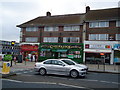
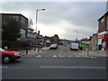
1
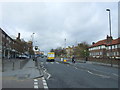
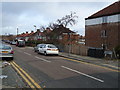
Edgware Road (A5)
Looking north west on the Roman Road.
Image: © JThomas
Taken: 18 Mar 2017
0.02 miles
2
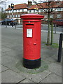
George V postbox on Edgware Road (A5)
Postbox No. HA8 736.
Image: © JThomas
Taken: 18 Mar 2017
0.03 miles
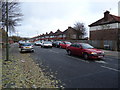
3
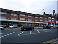
Car dealership, Holmstall Parade, Edgware Road, Burnt Oak
Image: © Stacey Harris
Taken: 27 Nov 2010
0.03 miles
6
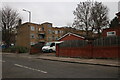
Montrose Avenue, Colindale
Looking towards the back of flats on Edgware Road
Image: © David Howard
Taken: 29 Dec 2020
0.04 miles
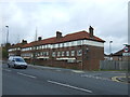
10
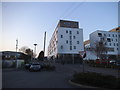
Avery House on Carlisle Road
The flats at this end are now complete, the tower at the other end is still being finished off.
Image: © David Howard
Taken: 23 Mar 2017
0.08 miles