IMAGES TAKEN NEAR TO
Burnt Oak Broadway, EDGWARE, HA8 5FB
Introduction
This page details the photographs taken nearby to Burnt Oak Broadway, HA8 5FB by members of the Geograph project.
The Geograph project started in 2005 with the aim of publishing, organising and preserving representative images for every square kilometre of Great Britain, Ireland and the Isle of Man.

There are currently over 7.5m images from over14,400 individuals and you can help contribute to the project by visiting https://www.geograph.org.uk
Image Map
Images are licensed for reuse under creativecommons.org/licenses/by-sa/2.0
Notes
- Clicking on the map will re-center to the selected point.
- The higher the marker number, the further away the image location is from the centre of the postcode.
Image Listing (51 Images Found)
Images are licensed for reuse under creativecommons.org/licenses/by-sa/2.0
Image
Details
Distance
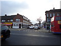
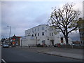
9
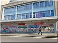
Poundstretcher on Stag Lane, Burnt Oak
This has been a number of large stores changing every few years since the 90s.
Image: © David Howard
Taken: 31 Mar 2022
0.10 miles
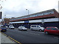
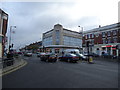
10
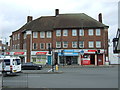
Watling Post Office
On Burnt Oak Broadway.
Image: © JThomas
Taken: 18 Mar 2017
0.11 miles