IMAGES TAKEN NEAR TO
Warren Lane, STANMORE, HA7 4LE
Introduction
This page details the photographs taken nearby to Warren Lane, HA7 4LE by members of the Geograph project.
The Geograph project started in 2005 with the aim of publishing, organising and preserving representative images for every square kilometre of Great Britain, Ireland and the Isle of Man.

There are currently over 7.5m images from over14,400 individuals and you can help contribute to the project by visiting https://www.geograph.org.uk
Image Map
Images are licensed for reuse under creativecommons.org/licenses/by-sa/2.0
Notes
- Clicking on the map will re-center to the selected point.
- The higher the marker number, the further away the image location is from the centre of the postcode.
Image Listing (21 Images Found)
Images are licensed for reuse under creativecommons.org/licenses/by-sa/2.0
Image
Details
Distance
1
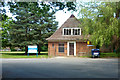
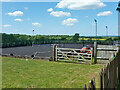
Disused lodge, Royal National Orthopaedic Hospital
The lodge at what appears to be a back entrance to the campus is boarded up with broken upper floor windows. This BBC news item from February 2015 is relevant: "The chief executive of the UK's national hospital for spinal surgery has warned it is on the brink of closure. Rob Hurd says it is being forced to treat patients at the Royal National Orthopaedic Hospital in Stanmore, north-west London, in buildings which are 'dying'".
Image: © Robin Webster
Taken: 7 Jun 2015
0.05 miles
3
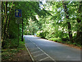
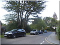
The Grove, HA7
Crossing an eastern arm of Stanmore Common.
Image: © Robin Webster
Taken: 7 Jun 2015
0.11 miles
4
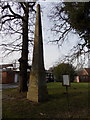
Stanmore: the obelisk within the grounds of the RNOH
The Royal National Orthopaedic Hospital inherited this historic obelisk in 1928 when it purchased 70 additional acres of land on this western side of the site.
The simple notice appears to have been produced longhand using a standard old-fashioned typewriter and explains the history of the obelisk in great depth:
THE OBELISK
The Obelisk was erected in 1750 by William Sharpe who was secretary to the second Duke of Chandos. It stands on what was the territory of the Catuvellauni, a dominant Celtic tribe whose king was Cassivellaunus, or Caswallon, as known to his people. The tribe occupied an area which is now Hertfordshire, Berkshire and Buckinghamshire, with the capital at Wheathampstead.
Julius Caesar invaded Britain with two legions in B.C.55, but went no further than Kent. In B.C.54 Caesar came again with five legions and 5000 cavalry and met strong resistance from the men of Kent. He crossed the Thames and advanced along a trackway through the forest. The fair-headed Britons in their scythed war chariots harassed the Roman columns. The legions also met string resistance from the Brythonic settlement and fortification of Sulloniacae whose site is near to the entrance to the Hospital grounds. It is conceivable that the Celtic inhabitants had dedicated their habitation to the goddess Sulis. It is not known what they named their settlement; Sulloniacae was the Roman way of rendering its Celtic name. The Roman army only advanced as far as Wheathampstead which was heroically defended by Cassivellaunus. After imposing a tribute Caesar and his army returned to Gaul. The tribute soon ceased to be paid.
Almost a century passed before another invasion took place although during the interval there was much intercourse between Britain and the Continent. The conquest of Gaul brought with it Latin civilization and Britain came within the orbit of Roman influence. In A.D.43 the Emperor Claudius began the conquest of Britain. He came with his troops along the road known as Sara Gwyddelin which means the Irish Highway. It went from Dover to Holyhead passing close to Sulloniacae on its way. The Romans spoke of "Gwyddelin" as "Weatlinga" which again became "Watling" to succeeding generations and thus "Sara Gwyddelin" became known as "Watling Street."
After the conquest the Romans usually allowed the tribes to be governed by their native rulers and the Celtic aristocracy were encouraged to adopt Roman dress, to speak Latin and were recognized as Roman citizens. By this means the goodwill of the native population was obtained and it continued for over three and a half centuries. Indeed the forced departure of the Romans in 410 by the threat to Rome by Alaric and the Goths was deplored. The Roman occupation left a permanent impression on the native language. Over 2000 Latin words were added to the Welsh vocabulary (e.g. "church" in Welsh is "eglwys", "bridge" is "pont" and "window" is "ffenestre.")
With the departure of the Romans the city of Gwerlam or Verulamium near the present St. Albans, ceased to be occupied. Its Roman bricks were used in the building of the great abbey.
TRANSLATION OF INSCRIPTIONS
ON THE SOUTH SIDE (front)
Near this place once stood the stronghold and township of the Suellani, a position splendidly fortified by nature and art. This tribe, under the leadership of Cassivellaunus, defeated the Romans. Caesar in his commentaries has put on record forever the greatness and renown of this British general, to whom by common consent the supreme command and conduct of the war has been entrusted.
This obelisk marks the midway point between Londinium (London), once a town of the Tribobantes and Verulamium (St. Albans) the principal township of the Cassi.
ON THE EAST SIDE
The present name of Brockley is not very different from the ancient Burgus, the higher ground towards which the eastern side looks.
ON THE WEST SIDE
This western side faces the old settlement of the Cassi, now called Cassiobury.
ON THE NORTH SIDE
Burgh Wood so called from Burgus, the stronghold of the leader Cassivellaunus, lies to the north.
Image: © Chris Downer
Taken: 2 Feb 2015
0.12 miles

7
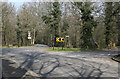
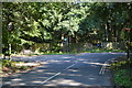
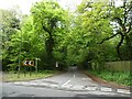
Junction on Warren Lane
On a sharp bend in Warren Lane two side roads diverge. On the right is Public Byway No.6 which leads to Grove Farm. On the left is The Grove which leads to a modern housing estate beside Stamnore Common.
Image: © Martin Addison
Taken: 8 Apr 2015
0.14 miles