IMAGES TAKEN NEAR TO
Wood Lane, STANMORE, HA7 4AP
Introduction
This page details the photographs taken nearby to Wood Lane, HA7 4AP by members of the Geograph project.
The Geograph project started in 2005 with the aim of publishing, organising and preserving representative images for every square kilometre of Great Britain, Ireland and the Isle of Man.

There are currently over 7.5m images from over14,400 individuals and you can help contribute to the project by visiting https://www.geograph.org.uk
Image Map
Images are licensed for reuse under creativecommons.org/licenses/by-sa/2.0
Notes
- Clicking on the map will re-center to the selected point.
- The higher the marker number, the further away the image location is from the centre of the postcode.
Image Listing (19 Images Found)
Images are licensed for reuse under creativecommons.org/licenses/by-sa/2.0
Image
Details
Distance
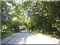
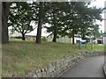
1
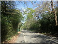
Wood Lane
This is approaching the entrance to the Royal National Orthopaedic Hospital.
Image: © Marathon
Taken: 20 Apr 2022
0.04 miles
2
The entrance to the Royal National Orthopaedic Hospital on Wood Lane
Image: © David Howard
Taken: 2 Sep 2014
0.06 miles
4
Stanmore: RNOH Friends? coffee bar
One of the many buildings scattered around the site of the Royal National Orthopædic Hospital, this is the coffee bar and small shop run by the Friends of the RNOH.
Image: © Chris Downer
Taken: 15 Jul 2008
0.09 miles
5
Stanmore: Royal National Orthop?dic Hospital
Considering that, as its name suggests, this hospital has many amputees and wheelchair users among its patients, it is not the most suitable of premises. It is a former military site, with distinctive old buildings of that ilk and a large array of prefabricated buildings. Here, we look at the main entrance and can see the ends of some of the prefab wards which are connected by a central corridor on a formidable gradient. It brings to mind the San Francisco streets portrayed in films, which are steep but level out at each frequent crossroads.
These wards are even called the "Slope wards" on the map in the Outpatients waiting room.
The operating theatres are at the very bottom, and one sure puts one's faith in the porters when one is being sent – literally – down!
Anyhow, plans are afoot to completely rebuild the hospital nearby, and a £16-million fundraising campaign is underway.
Image: © Chris Downer
Taken: 15 Jul 2008
0.09 miles
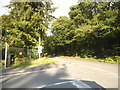
6
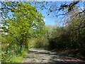
Wood Lane
This is just after passing the entrance to the Royal National Orthopaedic Hospital.
Image: © Marathon
Taken: 20 Apr 2022
0.09 miles
7
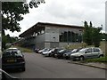
Stanmore: The Royal National Orthopaedic Hospital
The Royal National Orthopaedic Hospital NHS Trust provides a comprehensive range of neuro-musculoskeletal health care, ranging from the most acute spinal injury or complex bone tumour to orthopaedic medicine and specialist rehabilitation for chronic back pain sufferers. This broad range of neuro-musculoskeletal services is unique within the NHS. This is the "country" site set in 112 acres at Brockley Hill, Stanmore. The building in the photo is the Sir Herbert Seddon Teaching Centre, named after a famous surgeon. The Hospital's website can be found here http://www.rnoh-stanmore.org.uk/
Image: © Nigel Cox
Taken: 30 Nov 2005
0.10 miles
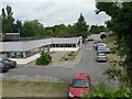
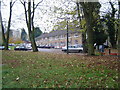
8

Wood Farm Close
This gated group of new housing is off Wood Lane to the east of Wood Farm.
Image: © Marathon
Taken: 20 Apr 2022
0.12 miles
9
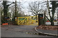
Private entrance to the Royal National Orthopaedic Hospital
Image: © David Howard
Taken: 6 Feb 2021
0.12 miles
10
Stanmore: Aspire centre
Situated within the grounds of Image, this is the Aspire centre – Aspire is a charity for spinally injured people, and this, their National Training Centre, aims to improve participation by disabled people in sport and leisure. It includes an internet café and a fitness lounge as well as a 25m swimming pool.
Image: © Chris Downer
Taken: 15 Jul 2008
0.12 miles