IMAGES TAKEN NEAR TO
Adhara Road, NORTHWOOD, HA6 3LR
Introduction
This page details the photographs taken nearby to Adhara Road, HA6 3LR by members of the Geograph project.
The Geograph project started in 2005 with the aim of publishing, organising and preserving representative images for every square kilometre of Great Britain, Ireland and the Isle of Man.

There are currently over 7.5m images from over14,400 individuals and you can help contribute to the project by visiting https://www.geograph.org.uk
Image Map
Images are licensed for reuse under creativecommons.org/licenses/by-sa/2.0
Notes
- Clicking on the map will re-center to the selected point.
- The higher the marker number, the further away the image location is from the centre of the postcode.
Image Listing (11 Images Found)
Images are licensed for reuse under creativecommons.org/licenses/by-sa/2.0
Image
Details
Distance
1
Maplewood Court, Eastbury
There are a number of upmarket gated apartment blocks like this one, Maplewood Court, on Eastbury Avenue. At the time of writing, a three-bedroomed flat here was on the market for just under £700,000 - enough to make anyone more used to provincial property prices wince.
Image: © Stephen McKay
Taken: 5 Apr 2022
0.11 miles
2

Beechcroft Place, Eastbury
Eastbury Avenue is lined with upmarket gated apartment blocks including this one, Beechcroft Place.
Image: © Stephen McKay
Taken: 5 Apr 2022
0.12 miles
3
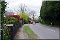
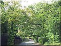
Watford Road, Northwood
The A4125 drops down towards the centre of Northwood in an area characterised by large gated properties set well back from the road.
Image: © Stephen McKay
Taken: 5 Apr 2022
0.17 miles
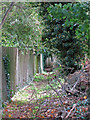
5

Footpath southeast of Mountview, Eastbury
Image: © Mike Quinn
Taken: 9 Oct 2019
0.19 miles
6

Cyclamen by the footpath south of Eastbury Avenue
Presumably garden escapees.
Image: © Mike Quinn
Taken: 9 Oct 2019
0.20 miles
8
Sandy Lane (A4125)
The observant might notice a very high security fence on the left-hand side of the road. And that the sign at the slight bend in the road in the distance says "Northwood Headquarters". What the bland sign doesn't say is that behind the fence are five military command and control functions https://en.wikipedia.org/wiki/Northwood_Headquarters :
Headquarters, Joint Forces Command https://en.wikipedia.org/wiki/Joint_Forces_Command ;
the Permanent Joint Headquarters https://en.wikipedia.org/wiki/Permanent_Joint_Headquarters ;
the Multi National Headquarters - this is for the command of European Union military operations;
the Commander Operations for the Royal Navy https://en.wikipedia.org/wiki/Commander_Operations_(Royal_Navy) ; and
the NATO Allied Maritime Command https://en.wikipedia.org/wiki/Allied_Maritime_Command which reports to the Allied Joint Force Command Brunssum https://en.wikipedia.org/wiki/Allied_Joint_Force_Command_Brunssum .
Directions for how to get there by bus, underground, rail, car and air, together with info about the dental facilities and the Mums and Toddlers group, can be found at https://en.wikipedia.org/wiki/Northwood_Headquarters .
Image: © Mike Quinn
Taken: 9 Oct 2019
0.22 miles
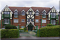
9
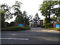
Erskine Hall care home, Watford Road
This is just before the border of London, while still in Northwood the area crosses both counties of London and Hertfordshire.
Image: © David Howard
Taken: 6 Sep 2012
0.22 miles
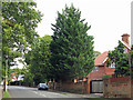
10
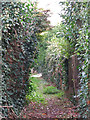
Footpath northwest of Watford Road (A4125)
Image: © Mike Quinn
Taken: 9 Oct 2019
0.22 miles