IMAGES TAKEN NEAR TO
Little Stream Close, NORTHWOOD, HA6 3LF
Introduction
This page details the photographs taken nearby to Little Stream Close, HA6 3LF by members of the Geograph project.
The Geograph project started in 2005 with the aim of publishing, organising and preserving representative images for every square kilometre of Great Britain, Ireland and the Isle of Man.

There are currently over 7.5m images from over14,400 individuals and you can help contribute to the project by visiting https://www.geograph.org.uk
Image Map
Images are licensed for reuse under creativecommons.org/licenses/by-sa/2.0
Notes
- Clicking on the map will re-center to the selected point.
- The higher the marker number, the further away the image location is from the centre of the postcode.
Image Listing (22 Images Found)
Images are licensed for reuse under creativecommons.org/licenses/by-sa/2.0
Image
Details
Distance
2
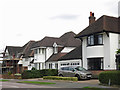
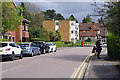
Eastbury Avenue, Northwood
Looking down Eastbury Avenue towards the junction with Eastbury Road, just inside the London Borough of Hillingdon. Little Stream Close leads off to the right.
Image: © Stephen McKay
Taken: 5 Apr 2022
0.05 miles
3
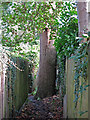
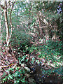
Small obstruction on the footpath west of Eastbury Road
Image: © Mike Quinn
Taken: 9 Oct 2019
0.07 miles
4
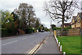
Eastbury Avenue
Eastbury Avenue passing Davenham Avenue
Image: © Shaun Ferguson
Taken: 13 May 2019
0.12 miles
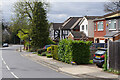
7
Eastbury Avenue, Eastbury
This area is the epitome of well-heeled leafy suburbia; Eastbury is just into Hertfordshire across the boundary from the London Borough of Hillingdon which includes Northwood. Ahead in this view is the junction with Davenham Avenue and the prominent apartment block is called Hollyoaks.
Image: © Stephen McKay
Taken: 5 Apr 2022
0.14 miles
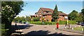
8
Davenham Avenue, Eastbury
This is the southern end of Davenham Avenue from its junction with Eastbury Avenue. The road runs through to Batchworth Lane. The land was once part of the Eastbury Estate, at the heart of which was the mansion house, whose site was to become RAF Northwood.
Image: © Stephen McKay
Taken: 5 Apr 2022
0.15 miles
9
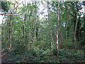
Scrubby land by the railway lines south of Batchworth Lane
Shows the location of Image
Image: © Mike Quinn
Taken: 9 Oct 2019
0.15 miles
10
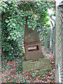
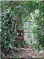
Coal tax boundary obelisk no.52, west of Eastbury Road (2)
See Image
Image: © Mike Quinn
Taken: 9 Oct 2019
0.15 miles