IMAGES TAKEN NEAR TO
Brookdene Drive, NORTHWOOD, HA6 3FG
Introduction
This page details the photographs taken nearby to Brookdene Drive, HA6 3FG by members of the Geograph project.
The Geograph project started in 2005 with the aim of publishing, organising and preserving representative images for every square kilometre of Great Britain, Ireland and the Isle of Man.

There are currently over 7.5m images from over14,400 individuals and you can help contribute to the project by visiting https://www.geograph.org.uk
Image Map
Images are licensed for reuse under creativecommons.org/licenses/by-sa/2.0
Notes
- Clicking on the map will re-center to the selected point.
- The higher the marker number, the further away the image location is from the centre of the postcode.
Image Listing (16 Images Found)
Images are licensed for reuse under creativecommons.org/licenses/by-sa/2.0
Image
Details
Distance
3
Gate End at the junction of Gatehill Road, Northwood
Image: © David Howard
Taken: 6 Sep 2012
0.19 miles
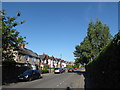
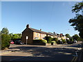
4
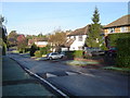
Northwood: Elgood Avenue
Viewed looking westwards.
Image: © Nigel Cox
Taken: 20 Nov 2005
0.19 miles
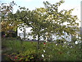
5
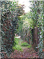
Footpath northwest of Watford Road (A4125)
Image: © Mike Quinn
Taken: 9 Oct 2019
0.20 miles
6
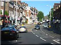
Town centre street scene Northwood
The railway station is at the top of the slope.
Image: © Jack Hill
Taken: 12 Jul 2005
0.20 miles
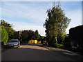
7
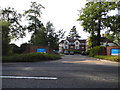
Erskine Hall care home, Watford Road
This is just before the border of London, while still in Northwood the area crosses both counties of London and Hertfordshire.
Image: © David Howard
Taken: 6 Sep 2012
0.21 miles
8
Junction of High Street and Chester Road
Image: © Basher Eyre
Taken: 12 Aug 2016
0.21 miles
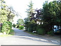
9

Footpath southeast of Mountview, Eastbury
Image: © Mike Quinn
Taken: 9 Oct 2019
0.21 miles