IMAGES TAKEN NEAR TO
South Approach, NORTHWOOD, HA6 2ET
Introduction
This page details the photographs taken nearby to South Approach, HA6 2ET by members of the Geograph project.
The Geograph project started in 2005 with the aim of publishing, organising and preserving representative images for every square kilometre of Great Britain, Ireland and the Isle of Man.

There are currently over 7.5m images from over14,400 individuals and you can help contribute to the project by visiting https://www.geograph.org.uk
Image Map
Images are licensed for reuse under creativecommons.org/licenses/by-sa/2.0
Notes
- Clicking on the map will re-center to the selected point.
- The higher the marker number, the further away the image location is from the centre of the postcode.
Image Listing (35 Images Found)
Images are licensed for reuse under creativecommons.org/licenses/by-sa/2.0
Image
Details
Distance
1
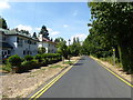
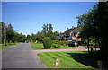
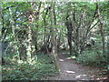
South Approach, Moor Park
The Moor Park Estate is around six square miles in size, with gated, private roads. It extends from Ruislip Woods through to Northwood, and finishes at Merchant Taylors' School. It was featured in John Betjeman's famed programme 'Metroland'.
South Approach appears to be part of the Estate in that like the other roads Google Streetview has not been down here, but there are no gates on this part. In this view, the woodland on the right shields the houses from the Metropolitan line - a linking footpath for the London LOOP from Moor Park station passes through the woodland.
Image: © Marathon
Taken: 25 Jul 2018
0.00 miles
2
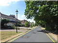
South Approach, Moor Park
South Approach, Moor Park
The Moor Park Estate is around six square miles in size, with gated, private roads. It extends from Ruislip Woods through to Northwood, and finishes at Merchant Taylors' School. It was featured in John Betjeman's famed programme 'Metroland'.
South Approach appears to be part of the Estate in that like the other roads Google Streetview has not been down here, but there are no gates on this part. In this view, the woodland on the right shields the houses from the Metropolitan line - a linking footpath for the London LOOP from Moor Park station passes through the woodland.
Image: © Marathon
Taken: 25 Jul 2018
0.07 miles
4
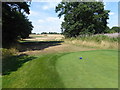
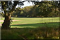
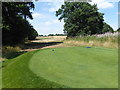
A green on Sandy Lodge Golf Course
Sandy Lodge Golf Course was founded in 1910. It was formed by a frustrated London businessman who was tired of playing golf on muddy parks around London and realised that the sandy soil of Sandy Lodge Farm would be perfect for playing golf. During the Second World War it was turned over to grazing but was restored afterwards although some of the sandy areas were lost to tree and shrub growth.
The London LOOP passes diagonally across the course from south-west to north-east although nearest to the former it is mostly rough grassland. This green on Sandy Lodge Golf Course is seen during the heatwave of 2018. While most of the course, like grassland everywhere at this time, was barren and brown the greens were lush and well-watered.
Image: © Marathon
Taken: 25 Jul 2018
0.10 miles
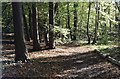
5
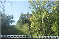
Moor Park: Footpath by Sandy Lodge Golf Club
This public footpath runs between the golf course beyond the trees to the right and the Metropolitan Line railway to the left, the grey boundary fence of which can just be seen. The path goes between Westbury Road and Moor Park Underground station.
Image: © Nigel Cox
Taken: 28 Jun 2009
0.10 miles
6
Green on Sandy Lodge Golf Course
Sandy Lodge Golf Course was founded in 1910. It was formed by a frustrated London businessman who was tired of playing golf on muddy parks around London and realised that the sandy soil of Sandy Lodge Farm would be perfect for playing golf. During the Second World War it was turned over to grazing but was restored afterwards although some of the sandy areas were lost to tree and shrub growth.
The London LOOP passes diagonally across the course from south-west to north-east although nearest to the former it is mostly rough grassland. This green on Sandy Lodge Golf Course is seen during the heatwave of 2018. While most of the course, like grassland everywhere at this time, was barren and brown the greens were lush and well-watered.
Image: © Marathon
Taken: 25 Jul 2018
0.10 miles