IMAGES TAKEN NEAR TO
Wolsey Road, NORTHWOOD, HA6 2EN
Introduction
This page details the photographs taken nearby to Wolsey Road, HA6 2EN by members of the Geograph project.
The Geograph project started in 2005 with the aim of publishing, organising and preserving representative images for every square kilometre of Great Britain, Ireland and the Isle of Man.

There are currently over 7.5m images from over14,400 individuals and you can help contribute to the project by visiting https://www.geograph.org.uk
Image Map
Images are licensed for reuse under creativecommons.org/licenses/by-sa/2.0
Notes
- Clicking on the map will re-center to the selected point.
- The higher the marker number, the further away the image location is from the centre of the postcode.
Image Listing (24 Images Found)
Images are licensed for reuse under creativecommons.org/licenses/by-sa/2.0
Image
Details
Distance
2
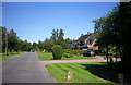
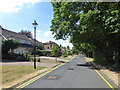
South Approach, Moor Park
The Moor Park Estate is around six square miles in size, with gated, private roads. It extends from Ruislip Woods through to Northwood, and finishes at Merchant Taylors' School. It was featured in John Betjeman's famed programme 'Metroland'.
South Approach appears to be part of the Estate in that like the other roads Google Streetview has not been down here, but there are no gates on this part. In this view, the woodland on the right shields the houses from the Metropolitan line - a linking footpath for the London LOOP from Moor Park station passes through the woodland.
Image: © Marathon
Taken: 25 Jul 2018
0.11 miles
4
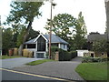
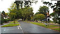
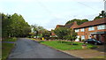
Modern house on Wolsey Road, Moor Park
Image: © David Howard
Taken: 11 Sep 2017
0.13 miles
7
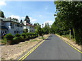
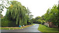
South Approach, Moor Park
South Approach, Moor Park
The Moor Park Estate is around six square miles in size, with gated, private roads. It extends from Ruislip Woods through to Northwood, and finishes at Merchant Taylors' School. It was featured in John Betjeman's famed programme 'Metroland'.
South Approach appears to be part of the Estate in that like the other roads Google Streetview has not been down here, but there are no gates on this part. In this view, the woodland on the right shields the houses from the Metropolitan line - a linking footpath for the London LOOP from Moor Park station passes through the woodland.
Image: © Marathon
Taken: 25 Jul 2018
0.17 miles
8
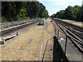
Looking south from Moor Park station
The Metropolitan Railway's extension to Rickmansworth from the previous terminus at Pinner was opened on 1st September 1887. However, although the stations either side opened then what is now Moor Park did not open until 9th May 1910 The station opened as "Sandy Lodge", named after the Sandy Lodge Golf Course which lies to the east. It was renamed as "Moor Park & Sandy Lodge" in 1923 to reflect the area it was in. The lines were electrified in 1925 when the Watford branch was opened and in 1950 the station was renamed again as "Moor Park". It was completely rebuilt in 1961.
What is now the Chiltern Line began as the Great Central Railway on 15th March 1899. The Great Central Railway provided services from Marylebone to destinations such as Rugby, Leicester, Nottingham and Manchester before the Beeching Axe cut them back to Aylesbury. They used the same tracks as the Metropolitan until 1962 when a pair of fast lines was added from Harrow-on-the-Hill to north of Moor Park.
This is the view south from the end of the stopping platforms with the down Metropolitan line on the right and the up line on the left. The next station in this direction is Northwood. The up fast line is immediately to the right of the down slow and the down fast is out of sight to the right. The fast lines are used by Chiltern Line trains and by some Metropolitan line trains.
Image: © Marathon
Taken: 25 Jul 2018
0.18 miles
9
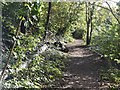
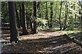
Footpath alongside the Metropolitan Line
Image: © N Chadwick
Taken: 27 Oct 2019
0.19 miles