IMAGES TAKEN NEAR TO
Bedford Road, NORTHWOOD, HA6 2BA
Introduction
This page details the photographs taken nearby to Bedford Road, HA6 2BA by members of the Geograph project.
The Geograph project started in 2005 with the aim of publishing, organising and preserving representative images for every square kilometre of Great Britain, Ireland and the Isle of Man.

There are currently over 7.5m images from over14,400 individuals and you can help contribute to the project by visiting https://www.geograph.org.uk
Image Map
Images are licensed for reuse under creativecommons.org/licenses/by-sa/2.0
Notes
- Clicking on the map will re-center to the selected point.
- The higher the marker number, the further away the image location is from the centre of the postcode.
Image Listing (17 Images Found)
Images are licensed for reuse under creativecommons.org/licenses/by-sa/2.0
Image
Details
Distance
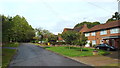
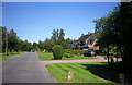
4
South Approach, Moor Park
The Moor Park Estate is around six square miles in size, with gated, private roads. It extends from Ruislip Woods through to Northwood, and finishes at Merchant Taylors' School. It was featured in John Betjeman's famed programme 'Metroland'.
South Approach appears to be part of the Estate in that like the other roads Google Streetview has not been down here, but there are no gates on this part. In this view, the woodland on the right shields the houses from the Metropolitan line - a linking footpath for the London LOOP from Moor Park station passes through the woodland.
Image: © Marathon
Taken: 25 Jul 2018
0.15 miles
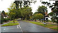
5
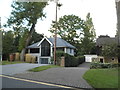
Modern house on Wolsey Road, Moor Park
Image: © David Howard
Taken: 11 Sep 2017
0.17 miles
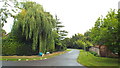
7
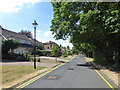
South Approach, Moor Park
South Approach, Moor Park
The Moor Park Estate is around six square miles in size, with gated, private roads. It extends from Ruislip Woods through to Northwood, and finishes at Merchant Taylors' School. It was featured in John Betjeman's famed programme 'Metroland'.
South Approach appears to be part of the Estate in that like the other roads Google Streetview has not been down here, but there are no gates on this part. In this view, the woodland on the right shields the houses from the Metropolitan line - a linking footpath for the London LOOP from Moor Park station passes through the woodland.
Image: © Marathon
Taken: 25 Jul 2018
0.20 miles
9
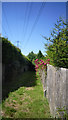
London Loop, Moor Park
The LOOP long distance path crosses this part of the Moor Park Estate on an undeveloped strip beneath the power cables.
Image: © Des Blenkinsopp
Taken: 23 Jul 2012
0.23 miles
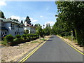
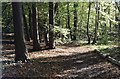
10
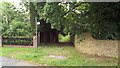
Public footpath, Moor Park
This path forms part of the London Loop long distance path.
Image: © Malc McDonald
Taken: 8 Sep 2013
0.24 miles