IMAGES TAKEN NEAR TO
The Drive, NORTHWOOD, HA6 1HN
Introduction
This page details the photographs taken nearby to The Drive, HA6 1HN by members of the Geograph project.
The Geograph project started in 2005 with the aim of publishing, organising and preserving representative images for every square kilometre of Great Britain, Ireland and the Isle of Man.

There are currently over 7.5m images from over14,400 individuals and you can help contribute to the project by visiting https://www.geograph.org.uk
Image Map
Images are licensed for reuse under creativecommons.org/licenses/by-sa/2.0
Notes
- Clicking on the map will re-center to the selected point.
- The higher the marker number, the further away the image location is from the centre of the postcode.
Image Listing (7 Images Found)
Images are licensed for reuse under creativecommons.org/licenses/by-sa/2.0
Image
Details
Distance
2
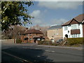
Farm Pinner Road
This was Robarts, then taken over by Express dairies now flats. my grandparents lived in house during the 1920's
Image: © pearl gardner
Taken: Unknown
0.12 miles
3

Potter Street School now Northwood School
This was called Potter Street school when I attended there.
Image: © pearl gardner
Taken: 16 Mar 2002
0.12 miles
4
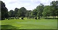
Path on Northwood Golf Course
Northwood Golf Club was founded in 1891 and, like Haste Hill Golf Course with which it has a common boundary to the east, it has a rolling profile. The two golf courses occupy a substantial area between Haste Hill and Northwood and are crossed by a number of footpaths. This footpath leads through a narrow strip of woodland to reach Haste Hill Golf Course a short way ahead and then passes the Haste Hill Clubhouse.
Image: © Marathon
Taken: 21 Mar 2018
0.16 miles
6
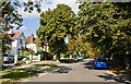
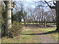
Chestnut Avenue
This avenue is, surprisingly, actually lined with Horse Chestnut trees along its length. It leads from the A404 Pinner Road to the entrance to Northwood Cemetery, the entrance to which is out of shot on the right. It also provides access to the allotments, recreation ground and Northwood FC's football ground.
Image: © Martin Addison
Taken: 12 Sep 2009
0.18 miles
7
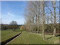
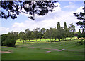
Footpath along the edge of Haste Hill Golf Course
Haste Hill Golf Course was designed by Harry Colt and opened in 1926. It includes a bird sanctuary and is on the western slope of Haste Hill. This is on a footpath which runs down from the top of Haste Hill.
Image: © Marathon
Taken: 21 Mar 2018
0.23 miles