IMAGES TAKEN NEAR TO
Hallowell Road, NORTHWOOD, HA6 1DU
Introduction
This page details the photographs taken nearby to Hallowell Road, HA6 1DU by members of the Geograph project.
The Geograph project started in 2005 with the aim of publishing, organising and preserving representative images for every square kilometre of Great Britain, Ireland and the Isle of Man.

There are currently over 7.5m images from over14,400 individuals and you can help contribute to the project by visiting https://www.geograph.org.uk
Image Map
Images are licensed for reuse under creativecommons.org/licenses/by-sa/2.0
Notes
- Clicking on the map will re-center to the selected point.
- The higher the marker number, the further away the image location is from the centre of the postcode.
Image Listing (33 Images Found)
Images are licensed for reuse under creativecommons.org/licenses/by-sa/2.0
Image
Details
Distance
6
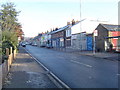
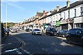
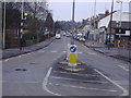
Northwood: High Street
Community shops, viewed looking northwards from the junction with the A404 Pinner Road.
Image: © Nigel Cox
Taken: 20 Nov 2005
0.08 miles
8
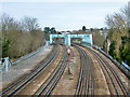
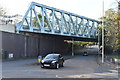
Metropolitan Line bridge MR60
A heavily built girder bridge crossing Rickmansworth Road (A404) on a severe skew. Viewed from bridge MR61.
Image: © Robin Webster
Taken: 1 Feb 2015
0.09 miles
9
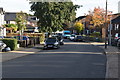
High Street Northwood
Like Teddington the road named 'High Street' in Northwood is not in fact the main street but a historic artifact.
Image: © David Howard
Taken: 4 Feb 2009
0.09 miles