IMAGES TAKEN NEAR TO
High Street, PINNER, HA5 5PZ
Introduction
This page details the photographs taken nearby to High Street, HA5 5PZ by members of the Geograph project.
The Geograph project started in 2005 with the aim of publishing, organising and preserving representative images for every square kilometre of Great Britain, Ireland and the Isle of Man.

There are currently over 7.5m images from over14,400 individuals and you can help contribute to the project by visiting https://www.geograph.org.uk
Image Map
Images are licensed for reuse under creativecommons.org/licenses/by-sa/2.0
Notes
- Clicking on the map will re-center to the selected point.
- The higher the marker number, the further away the image location is from the centre of the postcode.
Image Listing (173 Images Found)
Images are licensed for reuse under creativecommons.org/licenses/by-sa/2.0
Image
Details
Distance
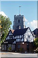
1
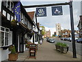
The Queen's Head, Pinner
The Queen's Head in Pinner was once a plastered building dated 1705, though the origins were much earlier. It bears the date 1580. It used to have railings and a porch with seats, altered in the early 1930s. The London coach used to leave here in the 19th century at 7:30 am for The Bull, Holborn, returning at 3:30, and arriving back in Pinner around 6pm. Early in the 20th century the licensee Dawson Billows kept a bear in the stables, sometimes he was seen taking it out for a walk.
Image: © Marathon
Taken: 27 Apr 2016
0.01 miles
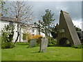
2
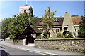
Pinner Church
The church, showing the churchyard. The bizarre structure is the Loudon monument, better known as "The coffin in the air."
Image: © Carl Grove
Taken: 22 Aug 1990
0.01 miles
3
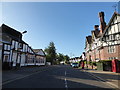
Looking from the High Street into Grange Gardens
Image: © Basher Eyre
Taken: 12 Aug 2016
0.01 miles
4
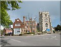
High Street, Pinner
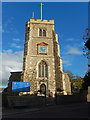
This view at the top of the High Street looks across to the Church of St John the Baptist, Pinner.
The battlemented west tower dates from the 15th century, while the body of the church dates from 1321 when it was consecrated by Bishop Petrus of Corbaria. The plan though goes back to the 13th century. The church was restored in 1880.
The obelisk on the far side of the churchyard was erected by John Claudius Loudon in 1843 to his parents. It consists of an arch cut in on each side at the foot, and higher up two ends of a fake coffin sticking out at the front and back.
For more about the church and the churchyard see http://www.pinnerparishchurch.org.uk/67.php
Image: © Marathon
Taken: 27 Apr 2016
0.02 miles
5
Pinner Church
Pinner Parish Church is dedicated to St John the Baptist. The first known reference to Pinner dates from 1232 but it was not until 1766 that it became an independent parish; prior to that this largely 14th century church was a chapel subordinate to St Mary's, Harrow on the Hill. As Pinner's population dramatically increased in the 20th century so did the importance of its church which is now the mother church of several neighbouring parishes. In this view taken on a bright Autumn day the clock on the 15th century tower is showing the correct time (properly reflecting the end of British summer time the previous day).
Image: © Stephen McKay
Taken: 29 Oct 2018
0.02 miles
6
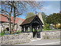
Entrance to St John the Baptist, Pinner
The battlemented west tower dates from the 15th century, while the body of the church dates from 1321 when it was consecrated by Bishop Petrus of Corbaria. The plan though goes back to the 13th century. The church was restored in 1880.
This view looks across Church Lane. The obelisk behind the lych gate was erected by John Claudius Loudon in 1843 to his parents. It consists of an arch cut in on each side at the foot, and higher up two ends of a fake coffin sticking out at the front and back. The tomb is known as “the coffin above the ground”. Loudon was a Victorian horticulturalist who came down from Scotland. He brought his parents from Scotland to help him manage Wood Hall Farm which he had bought in 1807. Loudon wrote 32 books and over four million words on horticulture and architecture. He introduced the plane tree to London squares, suggested green belts around towns, and laid out cemeteries and public parks. He made a fortune and lost it, dying “harassed by creditors”. His wife Amelia was the author of ‘The Ladies Flower Garden’.
For more about the church and the churchyard see http://www.pinnerparishchurch.org.uk/67.php
Image: © Marathon
Taken: 27 Apr 2016
0.02 miles
7
St John the Baptist, Pinner
The battlemented west tower of St John the Baptist Church dates from the 15th century, while the body of the church dates from 1321 when it was consecrated by Bishop Petrus of Corbaria. The plan though goes back to the 13th century. The church was restored in 1880.
The obelisk to the left of the lych gate was erected by John Claudius Loudon in 1843 to his parents. It consists of an arch cut in on each side at the foot, and higher up two ends of a fake coffin sticking out at the front and back. The tomb is known as “the coffin above the ground”. Loudon was a Victorian horticulturalist who came down from Scotland. He brought his parents from Scotland to help him manage Wood Hall Farm which he had bought in 1807. Loudon wrote 32 books and over four million words on horticulture and architecture. He introduced the plane tree to London squares, suggested green belts around towns, and laid out cemeteries and public parks. He made a fortune and lost it, dying “harassed by creditors”. His wife Amelia was the author of ‘The Ladies Flower Garden’.
For more about the church and the churchyard see https://www.pinnerparishchurch.org.uk/
Image: © Marathon
Taken: 27 Apr 2016
0.02 miles
8
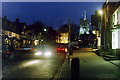
Pinner High Street
Night view of the High Street, the illuminated tower of Pinner Church in the background.
Image: © Carl Grove
Taken: 30 Mar 1996
0.02 miles
9
Pinner Church
The church tower overlooking wine bar, taken from the High Street
Image: © Carl Grove
Taken: 13 Oct 1994
0.02 miles
10
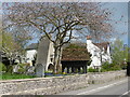
Pinner Churchyard and "the coffin above the ground"
The battlemented west tower of St John the Baptist Church dates from the 15th century, while the body of the church dates from 1321 when it was consecrated by Bishop Petrus of Corbaria. The plan though goes back to the 13th century. The church was restored in 1880.
The obelisk seen here is the best-known and most prominent object in the attractive churchyard. It was erected by John Claudius Loudon in 1843 to his parents. It consists of an arch cut in on each side at the foot, and higher up two ends of a fake coffin sticking out at the front and back. The tomb is known as “the coffin above the ground”. Loudon was a Victorian horticulturalist who came down from Scotland. He brought his parents from Scotland to help him manage Wood Hall Farm which he had bought in 1807. Loudon wrote 32 books and over four million words on horticulture and architecture. He introduced the plane tree to London squares, suggested green belts around towns, and laid out cemeteries and public parks. He made a fortune and lost it, dying “harassed by creditors”. His wife Amelia was the author of ‘The Ladies Flower Garden’.
For more about the church and the churchyard see https://www.pinnerparishchurch.org.uk/
Image: © Marathon
Taken: 27 Apr 2016
0.02 miles