St John the Baptist, Pinner
Introduction
The photograph on this page of St John the Baptist, Pinner by Marathon as part of the Geograph project.
The Geograph project started in 2005 with the aim of publishing, organising and preserving representative images for every square kilometre of Great Britain, Ireland and the Isle of Man.

There are currently over 7.5m images from over 14,400 individuals and you can help contribute to the project by visiting https://www.geograph.org.uk
St John the Baptist, Pinner
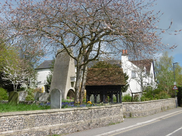
Image: © Marathon Taken: 27 Apr 2016
The battlemented west tower of St John the Baptist Church dates from the 15th century, while the body of the church dates from 1321 when it was consecrated by Bishop Petrus of Corbaria. The plan though goes back to the 13th century. The church was restored in 1880. The obelisk to the left of the lych gate was erected by John Claudius Loudon in 1843 to his parents. It consists of an arch cut in on each side at the foot, and higher up two ends of a fake coffin sticking out at the front and back. The tomb is known as “the coffin above the ground”. Loudon was a Victorian horticulturalist who came down from Scotland. He brought his parents from Scotland to help him manage Wood Hall Farm which he had bought in 1807. Loudon wrote 32 books and over four million words on horticulture and architecture. He introduced the plane tree to London squares, suggested green belts around towns, and laid out cemeteries and public parks. He made a fortune and lost it, dying “harassed by creditors”. His wife Amelia was the author of ‘The Ladies Flower Garden’. For more about the church and the churchyard see https://www.pinnerparishchurch.org.uk/
Images are licensed for reuse under creativecommons.org/licenses/by-sa/2.0
Image Location
Latitude
51.594408
Longitude
-0.379029