IMAGES TAKEN NEAR TO
Downs Avenue, PINNER, HA5 5AT
Introduction
This page details the photographs taken nearby to Downs Avenue, HA5 5AT by members of the Geograph project.
The Geograph project started in 2005 with the aim of publishing, organising and preserving representative images for every square kilometre of Great Britain, Ireland and the Isle of Man.

There are currently over 7.5m images from over14,400 individuals and you can help contribute to the project by visiting https://www.geograph.org.uk
Image Map
Images are licensed for reuse under creativecommons.org/licenses/by-sa/2.0
Notes
- Clicking on the map will re-center to the selected point.
- The higher the marker number, the further away the image location is from the centre of the postcode.
Image Listing (17 Images Found)
Images are licensed for reuse under creativecommons.org/licenses/by-sa/2.0
Image
Details
Distance
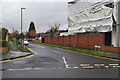
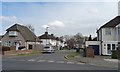
1
Cannon Lane Methodist Church
This started in 1956, in temporary premises, as a church for the rapidly developing community around Cannon Lane.
Image: © Christine Johnstone
Taken: 8 Mar 2016
0.17 miles
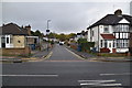
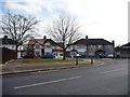
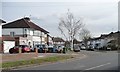
2
The north end of Durley Avenue
Looking eastwards from the junction with Cannon Lane.
Image: © Christine Johnstone
Taken: 8 Mar 2016
0.17 miles
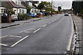
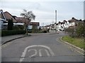
3
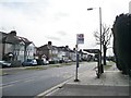
Bus stops on Cannon Lane
The nearer is for northbound buses heading towards Pinner.
Image: © Christine Johnstone
Taken: 8 Mar 2016
0.18 miles
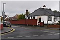
5
The southern end of Durley Avenue
At its junction with Cannon Lane.
Image: © Christine Johnstone
Taken: 8 Mar 2016
0.21 miles
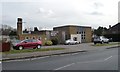
6
St Michael's Crescent
Running east from Cannon Lane.
Image: © Christine Johnstone
Taken: 8 Mar 2016
0.22 miles
7
Entrance to Chestnut Drive from Cannon Lane
This side road has an unusual semicircular off-set roundabout at its junction with Cannon Lane.
Image: © Christine Johnstone
Taken: 8 Mar 2016
0.22 miles