IMAGES TAKEN NEAR TO
Barrow Point Avenue, PINNER, HA5 3HQ
Introduction
This page details the photographs taken nearby to Barrow Point Avenue, HA5 3HQ by members of the Geograph project.
The Geograph project started in 2005 with the aim of publishing, organising and preserving representative images for every square kilometre of Great Britain, Ireland and the Isle of Man.

There are currently over 7.5m images from over14,400 individuals and you can help contribute to the project by visiting https://www.geograph.org.uk
Image Map
Images are licensed for reuse under creativecommons.org/licenses/by-sa/2.0
Notes
- Clicking on the map will re-center to the selected point.
- The higher the marker number, the further away the image location is from the centre of the postcode.
Image Listing (83 Images Found)
Images are licensed for reuse under creativecommons.org/licenses/by-sa/2.0
Image
Details
Distance
1
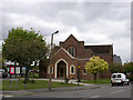
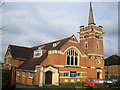
Pinner Methodist church
The church is situated at the junction of Love Lane and Avenue Road, and was built in 1937.
Image: © David Kemp
Taken: 30 Apr 2009
0.11 miles
2
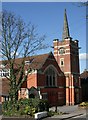
Pinner United Free Church (Baptist)
Situated in Paines Lane, this church is affiliated to the Baptist Union of Great Britain which was formed in 1891. It was built in 1908-9 in a style Pevsner describes as "cheerful Free Gothic".
Image: © David Kemp
Taken: 8 Apr 2010
0.12 miles
3
2016: a year on Geograph (Day 225)
Pinner Methodist Church
Image: © Basher Eyre
Taken: 12 Aug 2016
0.12 miles
4
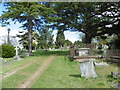
Pinner: Paines Lane Cemetery
This photograph was taken looking from the site of where the mortuary chapel once stood. The large memorial stone is completely anonymous, and does not appear to be the memorial to Horatia Nelson, the daughter of Lord Nelson, who is buried in the cemetery.
Image: © Nigel Cox
Taken: 5 Jun 2011
0.13 miles
5
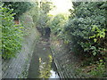
Woodridings Stream, Pinner
A tributary of the River Pinn, viewed looking upstream from the footpath between Barrow Point Avenue and Love Lane.
Image: © Nigel Cox
Taken: 20 Nov 2005
0.14 miles
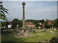
6
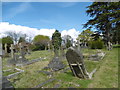
Paines Lane Cemetery
Paines Lane Cemetery opened in 1860, a modest cemetery without chapels or lodge and having a simple layout of cruciform walks. It was established here when efforts to enlarge Pinner's parish churchyard to provide burial ground for non-conformists failed. Among those buried here was Admiral Nelson's daughter Horatia. The cemetery was closed to burials in 1924.
A fuller description can be seen at http://www.londongardensonline.org.uk/gardens-online-record.asp?ID=HRW031
Image: © Marathon
Taken: 27 Apr 2016
0.14 miles
7
Paines Lane Cemetery
Paines Lane Cemetery opened in 1860, a modest cemetery without chapels or lodge and having a simple layout of cruciform walks. It was established here when efforts to enlarge Pinner's parish churchyard to provide burial ground for non-conformists failed. Among those buried here was Admiral Nelson's daughter Horatia. The cemetery was closed to burials in 1924.
A fuller description can be seen at http://www.londongardensonline.org.uk/gardens-online-record.asp?ID=HRW031
Image: © Marathon
Taken: 27 Apr 2016
0.14 miles
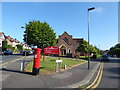
9
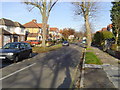
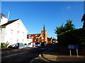
Pinner: Barrow Point Avenue
Viewed looking northwards
Image: © Nigel Cox
Taken: 20 Nov 2005
0.14 miles
10
Pinner United Free Church
On the west side of Paines Lane.
Image: © Nigel Cox
Taken: 23 Mar 2007
0.15 miles