IMAGES TAKEN NEAR TO
Love Lane, PINNER, HA5 3EX
Introduction
This page details the photographs taken nearby to Love Lane, HA5 3EX by members of the Geograph project.
The Geograph project started in 2005 with the aim of publishing, organising and preserving representative images for every square kilometre of Great Britain, Ireland and the Isle of Man.

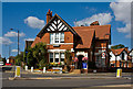
There are currently over 7.5m images from over14,400 individuals and you can help contribute to the project by visiting https://www.geograph.org.uk
Image Map
Images are licensed for reuse under creativecommons.org/licenses/by-sa/2.0
Notes
- Clicking on the map will re-center to the selected point.
- The higher the marker number, the further away the image location is from the centre of the postcode.
Image Listing (130 Images Found)
Images are licensed for reuse under creativecommons.org/licenses/by-sa/2.0
Image
Details
Distance
1
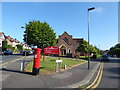
2016: a year on Geograph (Day 225)
Pinner Methodist Church
Image: © Basher Eyre
Taken: 12 Aug 2016
0.05 miles
2
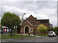
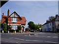
Pinner Methodist church
The church is situated at the junction of Love Lane and Avenue Road, and was built in 1937.
Image: © David Kemp
Taken: 30 Apr 2009
0.05 miles
4
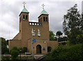
Catholic church of St Luke, Pinner
The church is situated in Love Lane. It was built in 1957 in a style Pevsner describes as neo-Romanesque.
Image: © David Kemp
Taken: 30 Apr 2009
0.07 miles
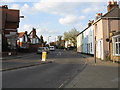
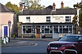
5
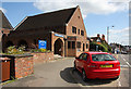
Pinner Police Station
Almost time to close for the day (13:00 on Saturdays). The floral display adds to the almost rural appearance of the small police station located on the corner of Waxwell Lane.
Image: © Martin Addison
Taken: 12 Sep 2009
0.08 miles
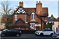
6
Pinner Police Station
This lovely old building is our Police Station, which is manned a few hours on week-days.
Image: © Alan Wilson
Taken: 30 May 2003
0.08 miles
7
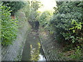
Woodridings Stream, Pinner
A tributary of the River Pinn, viewed looking upstream from the footpath between Barrow Point Avenue and Love Lane.
Image: © Nigel Cox
Taken: 20 Nov 2005
0.08 miles
8
Pinner Christian Science Church
Located at the top of the hill above the town centre on Elm Park Road.
Image: © Martin Addison
Taken: 12 Sep 2009
0.08 miles
10
Pinner Police Station
Grade II listed. https://historicengland.org.uk/listing/the-list/list-entry/1411163
Image: © N Chadwick
Taken: 27 Oct 2019
0.09 miles