IMAGES TAKEN NEAR TO
Hamlin Crescent, PINNER, HA5 2SU
Introduction
This page details the photographs taken nearby to Hamlin Crescent, HA5 2SU by members of the Geograph project.
The Geograph project started in 2005 with the aim of publishing, organising and preserving representative images for every square kilometre of Great Britain, Ireland and the Isle of Man.

There are currently over 7.5m images from over14,400 individuals and you can help contribute to the project by visiting https://www.geograph.org.uk
Image Map
Images are licensed for reuse under creativecommons.org/licenses/by-sa/2.0
Notes
- Clicking on the map will re-center to the selected point.
- The higher the marker number, the further away the image location is from the centre of the postcode.
Image Listing (5 Images Found)
Images are licensed for reuse under creativecommons.org/licenses/by-sa/2.0
Image
Details
Distance
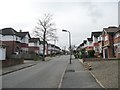
1
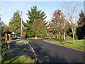
Eastcote: Cheney Street
Viewed looking northwards, Burwood Avenue to the left, Chiltern Road to the right.
Image: © Nigel Cox
Taken: 20 Nov 2005
0.10 miles
2
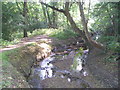
Celandine Way
Footpath beside the River Pinn.
Image: © Marion Phillips
Taken: 3 Jun 2011
0.20 miles
3
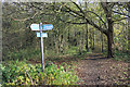
The Celandine Route in the Woods
The Celandine Route runs for twelve miles or so between Pinner and Uxbridge following the River Pinn. This section is especially pleasant with the river flowing through a long corridor of woodland quite secluded from the housing which is only a short distance away.
Image: © Des Blenkinsopp
Taken: 13 Nov 2018
0.20 miles
4
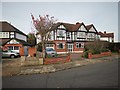
Eastcoat - Burwood Avenue
Large Victorian semi-detached houses.
Image: © James Emmans
Taken: 20 Nov 2019
0.22 miles
5
Colchester Drive
Looking south-west from Malpas Drive towards Rochester Drive.
Image: © Christine Johnstone
Taken: 8 Mar 2016
0.24 miles