IMAGES TAKEN NEAR TO
Bridle Road, PINNER, HA5 2SH
Introduction
This page details the photographs taken nearby to Bridle Road, HA5 2SH by members of the Geograph project.
The Geograph project started in 2005 with the aim of publishing, organising and preserving representative images for every square kilometre of Great Britain, Ireland and the Isle of Man.

There are currently over 7.5m images from over14,400 individuals and you can help contribute to the project by visiting https://www.geograph.org.uk
Image Map
Images are licensed for reuse under creativecommons.org/licenses/by-sa/2.0
Notes
- Clicking on the map will re-center to the selected point.
- The higher the marker number, the further away the image location is from the centre of the postcode.
Image Listing (3 Images Found)
Images are licensed for reuse under creativecommons.org/licenses/by-sa/2.0
Image
Details
Distance
1
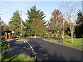
Eastcote: Cheney Street
Viewed looking northwards, Burwood Avenue to the left, Chiltern Road to the right.
Image: © Nigel Cox
Taken: 20 Nov 2005
0.17 miles
2
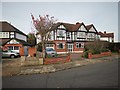
Eastcoat - Burwood Avenue
Large Victorian semi-detached houses.
Image: © James Emmans
Taken: 20 Nov 2019
0.23 miles
3
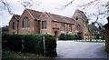
St. Lawrence Church, Eastcote Village
Image: © Nick Mutton 01329 000000
Taken: 26 Dec 1997
0.24 miles