IMAGES TAKEN NEAR TO
Theodora Way, PINNER, HA5 2RA
Introduction
This page details the photographs taken nearby to Theodora Way, HA5 2RA by members of the Geograph project.
The Geograph project started in 2005 with the aim of publishing, organising and preserving representative images for every square kilometre of Great Britain, Ireland and the Isle of Man.

There are currently over 7.5m images from over14,400 individuals and you can help contribute to the project by visiting https://www.geograph.org.uk
Image Map
Images are licensed for reuse under creativecommons.org/licenses/by-sa/2.0
Notes
- Clicking on the map will re-center to the selected point.
- The higher the marker number, the further away the image location is from the centre of the postcode.
Image Listing (40 Images Found)
Images are licensed for reuse under creativecommons.org/licenses/by-sa/2.0
Image
Details
Distance

2
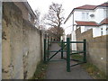
Path from Wiltshire Lane to Chestnut Avenue
Going around Northwood Cemetery between the two locations
Image: © David Howard
Taken: 2 Dec 2015
0.03 miles
3
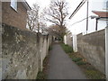
Path from Wiltshire Lane to Chestnut Avenue
The same as the previous one, but a little further along not showing the gates, which appear to make it impossible to access with a wheelchair.
Image: © David Howard
Taken: 2 Dec 2015
0.03 miles
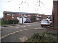
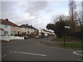
4
Wiltshire Lane, Northwood Hills
Norwich Road is on the right
Image: © David Howard
Taken: 2 Dec 2015
0.04 miles
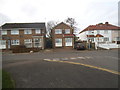
5
Wiltshire Lane at the corner of Norwich Road
Wiltshire Lane continues on the right
Image: © David Howard
Taken: 2 Dec 2015
0.05 miles

7
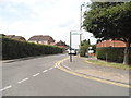
Fore Street at the junction of Wiltshire Lane
Image: © David Howard
Taken: 17 Jul 2014
0.05 miles