IMAGES TAKEN NEAR TO
Lime Grove, RUISLIP, HA4 8RJ
Introduction
This page details the photographs taken nearby to Lime Grove, HA4 8RJ by members of the Geograph project.
The Geograph project started in 2005 with the aim of publishing, organising and preserving representative images for every square kilometre of Great Britain, Ireland and the Isle of Man.

There are currently over 7.5m images from over14,400 individuals and you can help contribute to the project by visiting https://www.geograph.org.uk
Image Map
Images are licensed for reuse under creativecommons.org/licenses/by-sa/2.0
Notes
- Clicking on the map will re-center to the selected point.
- The higher the marker number, the further away the image location is from the centre of the postcode.
Image Listing (26 Images Found)
Images are licensed for reuse under creativecommons.org/licenses/by-sa/2.0
Image
Details
Distance
5
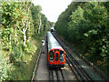
Metropolitan Line train nearing Eastcote
Composed of S8 stock, now the Metropolitan Line standard train.
Image: © Robin Webster
Taken: 29 Sep 2012
0.12 miles
6
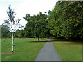
Path in Warrender Park
There is a gate from the park into Highgrove Wood beyond the hedge glimpsed on the left.
Image: © Robin Webster
Taken: 29 Sep 2012
0.12 miles
9
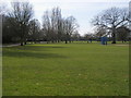
Warrender Park
Warrender Park above Myrtle Avenue
Image: © Shaun Ferguson
Taken: 24 Mar 2010
0.14 miles
10
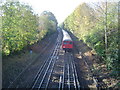
Metropolitan Line railway at Eastcote
An underground train, eastbound for Aldgate, approaches Eastcote station, viewed looking westwards from the Field End Road bridge.
Image: © Nigel Cox
Taken: 20 Nov 2005
0.17 miles