IMAGES TAKEN NEAR TO
St. Martins Approach, RUISLIP, HA4 7QQ
Introduction
This page details the photographs taken nearby to St. Martins Approach, HA4 7QQ by members of the Geograph project.
The Geograph project started in 2005 with the aim of publishing, organising and preserving representative images for every square kilometre of Great Britain, Ireland and the Isle of Man.

There are currently over 7.5m images from over14,400 individuals and you can help contribute to the project by visiting https://www.geograph.org.uk
Image Map (Loading...)


Getting Data...Please wait
Leaflet Map data © OpenStreetMap
Images are licensed for reuse under creativecommons.org/licenses/by-sa/2.0
Notes
- Clicking on the map will re-center to the selected point.
- The higher the marker number, the further away the image location is from the centre of the postcode.
Image Listing (21 Images Found)
Images are licensed for reuse under creativecommons.org/licenses/by-sa/2.0
Image
Details
Distance
1
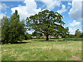
A stately oak
In the field behind St Martin's Approach.
Image: © Robin Webster
Taken: 31 Aug 2014
0.05 miles
2
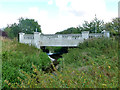
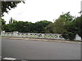
Bridge over River Pinn
St Martin's Approach crosses.
Image: © Robin Webster
Taken: 31 Aug 2014
0.08 miles
4
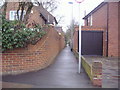
St Martins Approach
St Martins Approach passing Pinn Way
Image: © Shaun Ferguson
Taken: 24 Mar 2010
0.13 miles
5
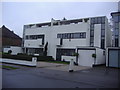
Houses on Park Avenue Ruislip
These houses date from 1936, and were designed by Connell, Ward and Lucas, described as "pioneer modernists" by Pevsner and Cherry in the Buildings of Britain (London 3: Northwest, published 1991).
Image: © David Howard
Taken: 16 Jan 2009
0.16 miles
6
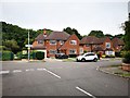
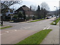
Ruislip - Sherwood Avenue junction with Broadwood Avenue
Footpath entrance to Ruislip Woods National Nature Reserve.
Wood info : https://en.wikipedia.org/wiki/Ruislip_Woods
Image: © James Emmans
Taken: 4 Aug 2019
0.16 miles
7
Pinn Way overlooking Manor Farm
Manor Farm includes a motte and bailey, and Winston Churchill Hall which is open for community events.
Image: © David Howard
Taken: 3 Sep 2013
0.17 miles
8
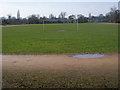
Kings College Playing Field
Kings College Playing Field track and football pitch
Image: © Shaun Ferguson
Taken: 24 Mar 2010
0.18 miles
9
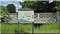
Celandine Route map
The Celandine Route is a 12-mile walk which follows the River Pinn from Pinner to the Grand Union Canal at Cowley. Hillingdon Council has provided maps and waymarking.
Image: © Mark Percy
Taken: 28 May 2022
0.18 miles
10
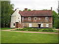
Ruislip: The Manor Farmhouse
This is a Grade II Listed Building and the English Heritage website describes it thus:-
"C16 timber framed building with C18 alterations. 2 storeys, 3 bays, and projecting gabled north wing. Old tiled roof with compound ridge stack and right end chimney. Close studded 1st floor with brick nogging. Ground floor now pebble-dashed. Sash windows with glazing bars, those on 1st floor in exposed moulded frames, those on ground floor in reveals. 6-panel door under flat hood. North wing stuccoed. Inside some exposed moulded beams."
Comparing this image with Pearl's Image from 2007 it is evident that the large coniferous trees concealing the north wing have been felled since then.
Image: © Nigel Cox
Taken: 16 May 2010
0.19 miles