IMAGES TAKEN NEAR TO
Northdown Close, RUISLIP, HA4 6JZ
Introduction
This page details the photographs taken nearby to Northdown Close, HA4 6JZ by members of the Geograph project.
The Geograph project started in 2005 with the aim of publishing, organising and preserving representative images for every square kilometre of Great Britain, Ireland and the Isle of Man.

There are currently over 7.5m images from over14,400 individuals and you can help contribute to the project by visiting https://www.geograph.org.uk
Image Map
Images are licensed for reuse under creativecommons.org/licenses/by-sa/2.0
Notes
- Clicking on the map will re-center to the selected point.
- The higher the marker number, the further away the image location is from the centre of the postcode.
Image Listing (29 Images Found)
Images are licensed for reuse under creativecommons.org/licenses/by-sa/2.0
Image
Details
Distance
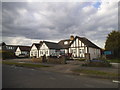
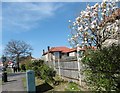
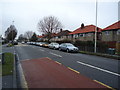
2
West End Road, Ruislip
Miles of housing like this all round here. It's hard to imagine what an enormous building site it must have all been during the 1930s.
Image: © Des Blenkinsopp
Taken: 13 Nov 2018
0.07 miles
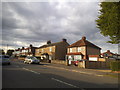
3
183 - 191 (odds) West End Road
Not typical of the road, but they are typical of the houses along Cornwall Road, a turning just beyond the end house on the left.
Image: © Robin Webster
Taken: 31 Aug 2014
0.10 miles
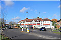
4
West End Road (A4180)
This is a hundred yards or so beyond the bridge at Ruislip Gardens station and just past Berkeley Close.
Image: © Marathon
Taken: 20 Apr 2016
0.12 miles
5
West End Road (A4180)
This is a hundred yards or so beyond the bridge at Ruislip Gardens station. Berkeley Close is on the right just ahead.
Image: © Marathon
Taken: 20 Apr 2016
0.13 miles
7
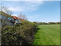
New Pond Farm Fields
New Pond Farm Fields are marked on the map as a recreation ground which frequently signifies a featureless open space and that certainly applies here. The Fields are basically sports pitches and the only vegetation, other than flat grass, is around the western and northern perimeters. This is the western edge with the backs of the houses in Berkeley Close to the left.
Image: © Marathon
Taken: 20 Apr 2016
0.16 miles
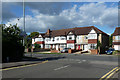
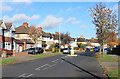
8
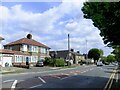
Ruislip: West End Road
Pretty typical of this suburban residential area. Most of the housing dates from the 1920's and 30's, with a great many 'semis'.
Image: © Stefan Czapski
Taken: 5 May 2022
0.19 miles
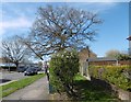
10
Cornwall Road, Ruislip
An unusual name, Ruislip (pronounced Rye-slip for anyone unfamiliar with London suburbs) is derived from Old English "rysc" - rush, and "slaep" - wet place. Rislep in the Domesday Book, Rushlep by 1315. (Oxford dictionary of place names)
Image: © Des Blenkinsopp
Taken: 13 Nov 2018
0.20 miles