IMAGES TAKEN NEAR TO
Thurlstone Road, RUISLIP, HA4 0BP
Introduction
This page details the photographs taken nearby to Thurlstone Road, HA4 0BP by members of the Geograph project.
The Geograph project started in 2005 with the aim of publishing, organising and preserving representative images for every square kilometre of Great Britain, Ireland and the Isle of Man.

There are currently over 7.5m images from over14,400 individuals and you can help contribute to the project by visiting https://www.geograph.org.uk
Image Map
Images are licensed for reuse under creativecommons.org/licenses/by-sa/2.0
Notes
- Clicking on the map will re-center to the selected point.
- The higher the marker number, the further away the image location is from the centre of the postcode.
Image Listing (18 Images Found)
Images are licensed for reuse under creativecommons.org/licenses/by-sa/2.0
Image
Details
Distance
1
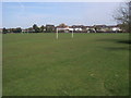
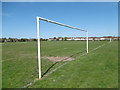
Football Pitches
Football pitches on New Pond Farm fields
Image: © Shaun Ferguson
Taken: 24 Mar 2010
0.06 miles
2
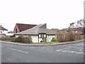
Ruislip Manor Methodist Church
The church is at the junction of Torrington road and Ashburton road. It was built in 1937. It is in the Harrow Circuit. It has many activities, and has rooms available for hire, from small rooms up to the hall for 100 and the church itself for 120. See church website http://www.rmmc.org.uk/.
Image: © David Hawgood
Taken: 3 Jan 2006
0.07 miles
3
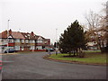
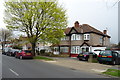
Ruislip Manor houses
This roundabout is at the junction of Victoria Road and Torrington Road
Image: © David Hawgood
Taken: 3 Jan 2006
0.12 miles
4
New Pond Farm Fields
New Pond Farm Fields are marked on the map as a recreation ground which frequently signifies a featureless open space and that certainly applies here. The Fields are basically sports pitches and the only vegetation, other than flat grass, is around the western and northern perimeters. See also http://www.geograph.org.uk/photo/4916469
Image: © Marathon
Taken: 20 Apr 2016
0.13 miles
5
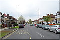
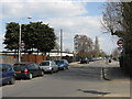
Bus stop and shelter on Victoria Road, Ruislip
Looking north west.
Image: © JThomas
Taken: 13 Apr 2019
0.15 miles
6
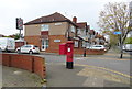
Houses on Victoria Road, Ruislip
Showing position of Postbox No. HA4 372.
See Image] for postbox.
Image: © JThomas
Taken: 13 Apr 2019
0.16 miles
7
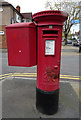
George VI postbox on Victoria Road, Ruislip
Postbox No. HA4 372.
See Image] for context.
Image: © JThomas
Taken: 13 Apr 2019
0.18 miles
8
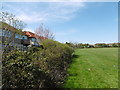
New Pond Farm Fields
New Pond Farm Fields are marked on the map as a recreation ground which frequently signifies a featureless open space and that certainly applies here. The Fields are basically sports pitches and the only vegetation, other than flat grass, is around the western and northern perimeters. This is the western edge with the backs of the houses in Berkeley Close to the left.
Image: © Marathon
Taken: 20 Apr 2016
0.19 miles