IMAGES TAKEN NEAR TO
HA3 9YJ
Introduction
This page details the photographs taken nearby to HA3 9YJ by members of the Geograph project.
The Geograph project started in 2005 with the aim of publishing, organising and preserving representative images for every square kilometre of Great Britain, Ireland and the Isle of Man.

There are currently over 7.5m images from over14,400 individuals and you can help contribute to the project by visiting https://www.geograph.org.uk
Image Map
Images are licensed for reuse under creativecommons.org/licenses/by-sa/2.0
Notes
- Clicking on the map will re-center to the selected point.
- The higher the marker number, the further away the image location is from the centre of the postcode.
Image Listing (43 Images Found)
Images are licensed for reuse under creativecommons.org/licenses/by-sa/2.0
Image
Details
Distance
1
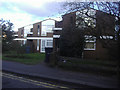
Duffield Close, Harrow
Typical 1960s modern houses
Image: © David Howard
Taken: 11 Feb 2010
0.08 miles
2
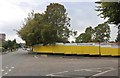
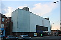
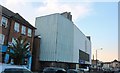
Demolition site on Crystal Way, Harrow
There was a low rise block of flats here, I expect far more to take their place.
Image: © David Howard
Taken: 28 Aug 2019
0.10 miles
6
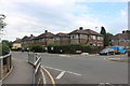
Bonnersfield Lane
Seen from the junction with Courtfield Avenue, looking towards the A409 Station Road / Sheepcote Road.
Image: © Martin Addison
Taken: 4 Apr 2014
0.13 miles
7
Manoush Persian restaurant on Sheepcote Road
Image: © David Howard
Taken: 16 Dec 2019
0.13 miles
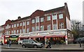
8
Industrial estate by Elmgrove Road, Harrow
Image: © David Howard
Taken: 28 Aug 2019
0.14 miles
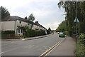
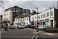
10
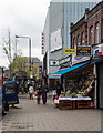
Station Road, Harrow
Pedestrians make their way past shops in the shadow of the Safari cinema which specialises in Bollywood films.
Image: © Martin Addison
Taken: 4 Apr 2014
0.16 miles