IMAGES TAKEN NEAR TO
Prestwood Close, HARROW, HA3 8JY
Introduction
This page details the photographs taken nearby to Prestwood Close, HA3 8JY by members of the Geograph project.
The Geograph project started in 2005 with the aim of publishing, organising and preserving representative images for every square kilometre of Great Britain, Ireland and the Isle of Man.

There are currently over 7.5m images from over14,400 individuals and you can help contribute to the project by visiting https://www.geograph.org.uk
Image Map
Images are licensed for reuse under creativecommons.org/licenses/by-sa/2.0
Notes
- Clicking on the map will re-center to the selected point.
- The higher the marker number, the further away the image location is from the centre of the postcode.
Image Listing (32 Images Found)
Images are licensed for reuse under creativecommons.org/licenses/by-sa/2.0
Image
Details
Distance
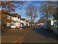
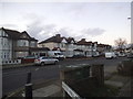
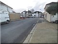
2
Kingshill Avenue
Part of the extensive semi-detached urban sprawl of Harrow.
Image: © James Emmans
Taken: 17 Nov 2019
0.12 miles
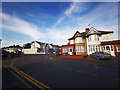
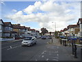
3
Becmead Avenue
Part of the London urban sprawl of Harrow.
The term "urban sprawl" was first used in an article in The Times in 1955 as a negative comment on the state of London's outskirts.
https://en.wikipedia.org/wiki/Urban_sprawl
Image: © James Emmans
Taken: 17 Nov 2019
0.15 miles
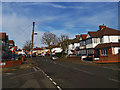
6
Kenton Lane
The southern end, heading north to Stanmore and Wealdstone
Image: © David Howard
Taken: 23 Dec 2015
0.19 miles
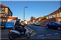
7
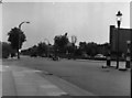
Kenton Library, Harrow, Middlesex
Looking southwards down Kenton Lane, with the Library on the right. The RLH-class bus is on route 230 from Northwick Park station to Rayners Lane, but there's very little other traffic in this 1955 view.
Image: © Dr Neil Clifton
Taken: 10 Jun 1955
0.19 miles
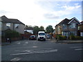
9
Kenton Park Road
This was a way around the Kenton Road/Kenton Lane traffic lights, so they blocked it and now the lights are queueing most of the day as a direct result. It has probably added 5-10 minutes to the average journey.
Image: © David Howard
Taken: 23 Dec 2015
0.21 miles
10
London Borough of Harrow : Rowland Avenue
Looking along Rowland Avenue off of Kenton Lane.
Image: © Lewis Clarke
Taken: 3 Oct 2018
0.21 miles