IMAGES TAKEN NEAR TO
Old Redding, HARROW, HA3 6SH
Introduction
This page details the photographs taken nearby to Old Redding, HA3 6SH by members of the Geograph project.
The Geograph project started in 2005 with the aim of publishing, organising and preserving representative images for every square kilometre of Great Britain, Ireland and the Isle of Man.

There are currently over 7.5m images from over14,400 individuals and you can help contribute to the project by visiting https://www.geograph.org.uk
Image Map
Images are licensed for reuse under creativecommons.org/licenses/by-sa/2.0
Notes
- Clicking on the map will re-center to the selected point.
- The higher the marker number, the further away the image location is from the centre of the postcode.
Image Listing (39 Images Found)
Images are licensed for reuse under creativecommons.org/licenses/by-sa/2.0
Image
Details
Distance
1
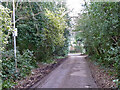
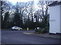
Brookshill Drive
A private road but public footpath.
Image: © Robin Webster
Taken: 23 Feb 2013
0.05 miles
2
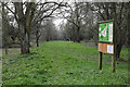
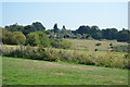
Footpath on Harrow Weald Common
Seen from Old Redding.
Image: © Martin Addison
Taken: 8 Apr 2015
0.08 miles
3
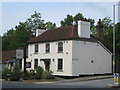
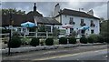
Harrow Weald: The Hare
Along with its old stable block to the left and with its symmetrical front The Hare is a Grade II Listed Building, at the junction of Old Redding to the right and Brookshill to the left.
Image: © Nigel Cox
Taken: 5 Jun 2011
0.09 miles
4
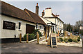
The Hare
A public house located on Brookshill at the junction with Old Redding and Clamps Hill.
Image: © Martin Addison
Taken: 8 Apr 2015
0.09 miles
6
Old Redding at junction of Brookshill, Harrow Weald
Image: © David Howard
Taken: 16 Feb 2011
0.10 miles
8
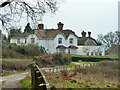
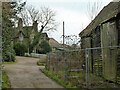
Brookshill Cottages
It looks like one house now.
Image: © Robin Webster
Taken: 23 Feb 2013
0.11 miles
9
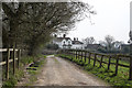
Bridleway by Copse Farm
The decrepit barn is part of the farm buildings, which are off to the right.
Image: © Robin Webster
Taken: 23 Feb 2013
0.11 miles
10
Byway to Copse Farm
Looking along the public byway that leads from Old Redding to Copse Farm. Beyond the farm the byway becomes a footpath that descends the eastern side of the valley carved by the upper reaches of the River Pinn.
Image: © Martin Addison
Taken: 8 Apr 2015
0.11 miles