IMAGES TAKEN NEAR TO
Ilmington Road, HARROW, HA3 0NH
Introduction
This page details the photographs taken nearby to Ilmington Road, HA3 0NH by members of the Geograph project.
The Geograph project started in 2005 with the aim of publishing, organising and preserving representative images for every square kilometre of Great Britain, Ireland and the Isle of Man.

There are currently over 7.5m images from over14,400 individuals and you can help contribute to the project by visiting https://www.geograph.org.uk
Image Map
Images are licensed for reuse under creativecommons.org/licenses/by-sa/2.0
Notes
- Clicking on the map will re-center to the selected point.
- The higher the marker number, the further away the image location is from the centre of the postcode.
Image Listing (21 Images Found)
Images are licensed for reuse under creativecommons.org/licenses/by-sa/2.0
Image
Details
Distance
1
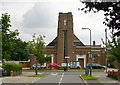
St John's United Reformed church, Kenton
The church is situated in Woodcock Hill and the picture taken from Dovedale Avenue.
Image: © David Kemp
Taken: 21 Jul 2011
0.04 miles
3
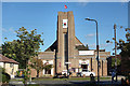
Church to Temple
Previously Geographed as St John's United Reformed church, Image this is now the Haridham Hindu Swaminarayam Temple.
Image: © Des Blenkinsopp
Taken: 2 Oct 2019
0.05 miles
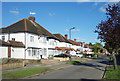
6
Woodcock Park
Woodcock Park formed part of the grounds of Kenton Grange built as Kenton Lodge in 1803. Open to the public in 1952, the park is a popular recreation area. It is divided into two sections by the Wealdstone Brook, a tributary of the Brent. Normally confined to culverts or concrete ditches, the brook can be seen in a semi natural state for a few hundred metres through the middle of the park.
Image: © Des Blenkinsopp
Taken: 2 Oct 2019
0.12 miles
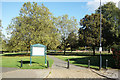
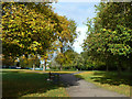
7
Signs of autumn, Woodcock Park
A Brent Council park.
Image: © Robin Webster
Taken: 13 Oct 2012
0.15 miles
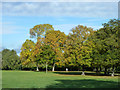
8
Shaded path, Woodcock Park
A Brent Council park.
Image: © Robin Webster
Taken: 13 Oct 2012
0.16 miles
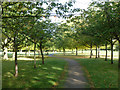
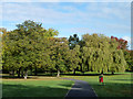
9
Path, Woodcock Park
A Brent Council park.
Image: © Robin Webster
Taken: 13 Oct 2012
0.16 miles
10
Path, Woodcock Park
A Brent Council park.
Image: © Robin Webster
Taken: 13 Oct 2012
0.16 miles