IMAGES TAKEN NEAR TO
Churchill Avenue, HARROW, HA3 0AX
Introduction
This page details the photographs taken nearby to Churchill Avenue, HA3 0AX by members of the Geograph project.
The Geograph project started in 2005 with the aim of publishing, organising and preserving representative images for every square kilometre of Great Britain, Ireland and the Isle of Man.

There are currently over 7.5m images from over14,400 individuals and you can help contribute to the project by visiting https://www.geograph.org.uk
Image Map
Images are licensed for reuse under creativecommons.org/licenses/by-sa/2.0
Notes
- Clicking on the map will re-center to the selected point.
- The higher the marker number, the further away the image location is from the centre of the postcode.
Image Listing (140 Images Found)
Images are licensed for reuse under creativecommons.org/licenses/by-sa/2.0
Image
Details
Distance
1
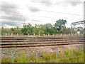
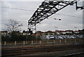
London Borough of Brent : West Coast Main Line
Looking across towards the West Coast Main Line.
Image: © Lewis Clarke
Taken: 18 Jul 2019
0.05 miles
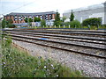
2
London Borough of Brent : West Coast Main Line
Looking along the tracks of the West Coast Main Line.
Image: © Lewis Clarke
Taken: 18 Jul 2019
0.06 miles
3
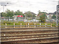
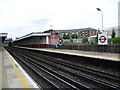
London Borough of Brent : Kenton Station
Kenton is a National Rail suburban rail station on the Watford DC line and the London Underground Bakerloo line, situated on Kenton Road in Kenton, north-west London.
Image: © Lewis Clarke
Taken: 18 Jul 2019
0.06 miles
4
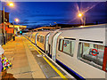
Kenton Station
Kenton Station opened in June 1912. London Overground and Bakerloo Line trains stop here while National Rail services from Euston by pass it on the far side. https://en.wikipedia.org/wiki/Kenton_station
Image: © Des Blenkinsopp
Taken: 2 Oct 2019
0.07 miles
5
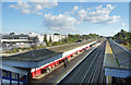
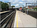
Kenton station
The London & Birmingham Railway opened from Euston to Boxmoor in 1837 and on to Birmingham in 1838. In 1846 it became part of the London & North Western Railway. Suburban trains were diverted from 15th June 1912 to run over the "New Lines", which had just been built between Euston and Watford Junction. These are the route used today by Bakerloo and Overground trains. Kenton station opened on the same day. Bakerloo line services began on 16th April 1917.
The fast lines are beyond the station to the right here and this, with South Kenton, is one of the best train-spotting stations in London. There have never been station buildings on the fast lines. Beyond the fast lines on the far right is a Sainsbury's supermarket, built on the station's former coal yard.
Image: © Marathon
Taken: 5 Aug 2015
0.07 miles
7
Kenton railway and Underground station, Greater London
Opened in 1912 by the London & North Western Railway on its line from London Euston to Watford Junction.
View north west towards Harrow & Wealdstone and Watford Junction. The main lines are behind the fence on the right. The station is also used by Bakerloo line trains. Like 55% of the London Underground network, this part is actually overground.
Image: © Nigel Thompson
Taken: 3 Sep 2009
0.08 miles
8
Corner of Rushout Avenue, Northwick Park
Image: © David Howard
Taken: 11 Sep 2007
0.08 miles

10
Looking across the fast lines at Kenton station
The London & Birmingham Railway opened from Euston to Boxmoor in 1837 and on to Birmingham in 1838. In 1846 it became part of the London & North Western Railway. Suburban trains were diverted from 15th June 1912 to run over the "New Lines", which had just been built between Euston and Watford Junction. These are the route used today by Bakerloo and Overground trains. Kenton station opened on the same day. Bakerloo line services began on 16th April 1917.
The fast lines are seen beyond the station here and this, with South Kenton, is one of the best train-spotting stations in London. There have never been station buildings on the fast lines. Beyond on the right is a Sainsbury's supermarket, built on the station's former coal yard.
Image: © Marathon
Taken: 5 Aug 2015
0.08 miles