IMAGES TAKEN NEAR TO
Southfield Park, HARROW, HA2 6HE
Introduction
This page details the photographs taken nearby to Southfield Park, HA2 6HE by members of the Geograph project.
The Geograph project started in 2005 with the aim of publishing, organising and preserving representative images for every square kilometre of Great Britain, Ireland and the Isle of Man.

There are currently over 7.5m images from over14,400 individuals and you can help contribute to the project by visiting https://www.geograph.org.uk
Image Map
Images are licensed for reuse under creativecommons.org/licenses/by-sa/2.0
Notes
- Clicking on the map will re-center to the selected point.
- The higher the marker number, the further away the image location is from the centre of the postcode.
Image Listing (29 Images Found)
Images are licensed for reuse under creativecommons.org/licenses/by-sa/2.0
Image
Details
Distance
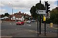
1
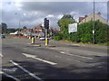
Pinner Road at the junction of Southfield Park
Image: © David Howard
Taken: 22 Aug 2012
0.11 miles
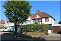
2
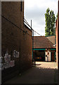
Private Road, North Harrow
A narrow private road leading to garages and workshops behind the shopping parade on the Pinner Road.
Image: © Martin Addison
Taken: 12 Sep 2009
0.13 miles
4
North Harrow Methodist church, Pinner Road
Image: © David Howard
Taken: 22 Aug 2012
0.14 miles
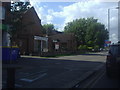
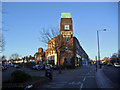
5
Wealdstone Motors
Located in North Harrow on the Pinner Road. This is the rear of the building, on Woodlands.
Image: © Martin Addison
Taken: 12 Sep 2009
0.14 miles

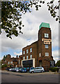
8
Wealdstone Motors building, Pinner Road
Image: © David Howard
Taken: 26 Dec 2008
0.15 miles
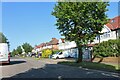
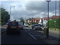
10
Headstone Lane
Seen from the junction with Pinner Road, on the right, and George V Avenue on the left. The cars coming straight across the junction are joining the Pinner Road which bends sharply left here.
Image: © Martin Addison
Taken: 12 Sep 2009
0.16 miles