IMAGES TAKEN NEAR TO
Crofts Road, HARROW, HA1 2PQ
Introduction
This page details the photographs taken nearby to Crofts Road, HA1 2PQ by members of the Geograph project.
The Geograph project started in 2005 with the aim of publishing, organising and preserving representative images for every square kilometre of Great Britain, Ireland and the Isle of Man.

There are currently over 7.5m images from over14,400 individuals and you can help contribute to the project by visiting https://www.geograph.org.uk
Image Map
Images are licensed for reuse under creativecommons.org/licenses/by-sa/2.0
Notes
- Clicking on the map will re-center to the selected point.
- The higher the marker number, the further away the image location is from the centre of the postcode.
Image Listing (13 Images Found)
Images are licensed for reuse under creativecommons.org/licenses/by-sa/2.0
Image
Details
Distance
1
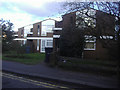
Duffield Close, Harrow
Typical 1960s modern houses
Image: © David Howard
Taken: 11 Feb 2010
0.15 miles
2
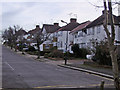
Elmwood Avenue, Kenton
Typical 1930s suburban Middlesex houses
Image: © David Howard
Taken: 15 Feb 2007
0.17 miles
3
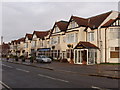
Northwick Park Road
Some of the "houses" are a hotel
Image: © David Hawgood
Taken: 1 Jan 2006
0.19 miles
4
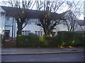
Arts and crafts houses, Northwick Park Road
Image: © David Howard
Taken: 11 Feb 2010
0.19 miles
5
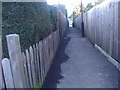
Footpath from Hawthorne Avenue to Gerard Road, Harrow
Image: © David Howard
Taken: 11 Feb 2010
0.20 miles
6
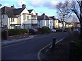
Hawthorne Avenue
Looking south towards Kenton Road
Image: © David Howard
Taken: 11 Feb 2010
0.21 miles
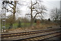
7

Bombardier Class 221 at Kenton
Carrying a special variation of Virgin Trains livery advertising manufacturer Bombardier, Super Voyager diesel-electric unit 221115 approaches Kenton at speed. It is operating the 09:35 (1A18) service from Chester and is due to arrive at Euston at 11:36.
Image: © Martin Addison
Taken: 4 Apr 2014
0.22 miles
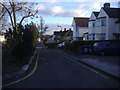
10
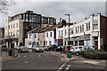
Bonnersfield Lane
Seen from the junction with Courtfield Avenue, looking towards the A409 Station Road / Sheepcote Road.
Image: © Martin Addison
Taken: 4 Apr 2014
0.24 miles