IMAGES TAKEN NEAR TO
Queen Victoria Avenue, WEMBLEY, HA0 4RW
Introduction
This page details the photographs taken nearby to Queen Victoria Avenue, HA0 4RW by members of the Geograph project.
The Geograph project started in 2005 with the aim of publishing, organising and preserving representative images for every square kilometre of Great Britain, Ireland and the Isle of Man.

There are currently over 7.5m images from over14,400 individuals and you can help contribute to the project by visiting https://www.geograph.org.uk
Image Map
Images are licensed for reuse under creativecommons.org/licenses/by-sa/2.0
Notes
- Clicking on the map will re-center to the selected point.
- The higher the marker number, the further away the image location is from the centre of the postcode.
Image Listing (39 Images Found)
Images are licensed for reuse under creativecommons.org/licenses/by-sa/2.0
Image
Details
Distance
3
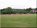
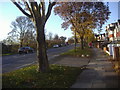
One Tree Hill recreation ground, Wembley
From the top of Bowrons Avenue, looking West to Horsenden Hill
Image: © David Hawgood
Taken: 30 Jun 2005
0.11 miles
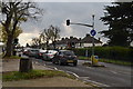
5
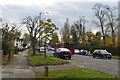
Bridgewater Road, Sudbury
Looking towards Sudbury Town.
Image: © David Howard
Taken: 11 Nov 2008
0.12 miles
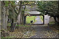
8
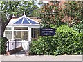
Alperton Cemetery
Alperton Cemetery Office
Clifford Road
Alperton
Middlesex
Image: © Russell Trebor
Taken: 24 Jun 2006
0.15 miles
9
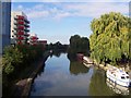
The Grand Union Canal - Alperton
Viewed from Canal Bridge looking towards Perivale
Image: © Russell Trebor
Taken: 24 Sep 2006
0.16 miles
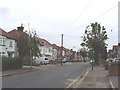
10
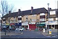
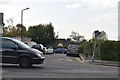
Sudbury Heights Ave
Shops at Sudbury Town end of Road
Image: © Russell Trebor
Taken: 3 Dec 2006
0.16 miles