IMAGES TAKEN NEAR TO
Norval Road, WEMBLEY, HA0 3SX
Introduction
This page details the photographs taken nearby to Norval Road, HA0 3SX by members of the Geograph project.
The Geograph project started in 2005 with the aim of publishing, organising and preserving representative images for every square kilometre of Great Britain, Ireland and the Isle of Man.

There are currently over 7.5m images from over14,400 individuals and you can help contribute to the project by visiting https://www.geograph.org.uk
Image Map
Images are licensed for reuse under creativecommons.org/licenses/by-sa/2.0
Notes
- Clicking on the map will re-center to the selected point.
- The higher the marker number, the further away the image location is from the centre of the postcode.
Image Listing (81 Images Found)
Images are licensed for reuse under creativecommons.org/licenses/by-sa/2.0
Image
Details
Distance
1
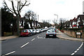
South Kenton: north end of Nathans Road
At its northerly end, Nathans Road leads onto the open space of Northwick Park, where it is a pleasant walk across to Harrow Hill, although not as pleasant now as it was fifty years ago before the hospital and college had been built. Most of the houses in Nathans Road retain the mock-tudor fronts they were given when the Sudbury Court estate was laid out here in the 1930s, but some dilution of these has occurred, even though this is a Consrvation area.
Image: © Dr Neil Clifton
Taken: 4 Mar 2010
0.06 miles
2
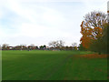
Football Pitch on Northwick Park
Park of a large open park area.
Image: © James Emmans
Taken: 17 Nov 2019
0.06 miles
4
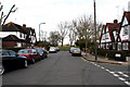
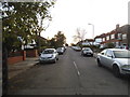
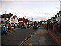
South Kenton: Norval Road
Looking west from its junction with Nathans Road, Norval Road runs round to join Carlton Avenue West at its far end very close to its junction with Watford Road (A404). Most of these roads are now 'humped' and this has greatly reduced the number of learner-drivers being brought here by motoring schools. However the parking problem remains, due to the proximity of South Kenton station with its frequent services.
Image: © Dr Neil Clifton
Taken: 4 Mar 2010
0.08 miles
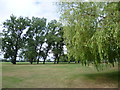
5
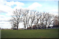
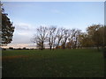
Northwick Park: Trees and football pitches
Image: © Dr Neil Clifton
Taken: 4 Mar 2010
0.08 miles
6
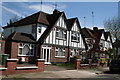
100 and 98, Nathans Road, South Kenton
The large Sudbury Court estate was built around 1930. This pair of well-maintained semis retain very well the original attractive appearance of the houses.
Image: © Dr Neil Clifton
Taken: 6 Apr 2011
0.08 miles
7
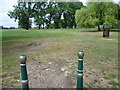
The Fairway at the entrance to Northwick Park
Image: © David Howard
Taken: 7 Nov 2014
0.09 miles
8
The entrance to Northwick Park
What is now Northwick Park was the fields of Sheepcote Farm until the 20th century. The park is named after the Lord of the Manor of Harrow Lord Northwick, the largest landowner in the district in the early 19th century. He lived at Northwick Park, a mansion at Blockley in Worcestershire. Lord Northwick enclosed the commons in the Harrow area with great enthusiasm. This added to the suffering of the agricultural labourers of the area who faced a multitude of other problems. Lord Northwick was probably the most hated man in the area and it is strange that a park which is now of benefit to all commemorates somebody who tried to deny local people access to this land.
Sheepcote Farm was the home of Thomas Grimwade, farmer and inventor of desiccated milk, which was shipped out to Florence Nightingale in the Crimean War.
In 1905, the Harrow School Land Trust obtained most of Sheepcote Farm to prevent it being developed. In 1936, Middlesex County Council and Wembley Urban District Council purchased the Northwick Park Estate as additional open space for the people of Wembley.
This view is at the south-east corner by the entrance from Nathans Road. It is just round the corner from South Kenton station.
Image: © Marathon
Taken: 15 Jul 2015
0.09 miles
10
Northwick Park
What is now Northwick Park was the fields of Sheepcote Farm until the 20th century. The park is named after the Lord of the Manor of Harrow Lord Northwick, the largest landowner in the district in the early 19th century. He lived at Northwick Park, a mansion at Blockley in Worcestershire. Lord Northwick enclosed the commons in the Harrow area with great enthusiasm. This added to the suffering of the agricultural labourers of the area who faced a multitude of other problems. Lord Northwick was probably the most hated man in the area and it is strange that a park which is now of benefit to all commemorates somebody who tried to deny local people access to this land.
Sheepcote Farm was the home of Thomas Grimwade, farmer and inventor of desiccated milk, which was shipped out to Florence Nightingale in the Crimean War.
In 1905, the Harrow School Land Trust obtained most of Sheepcote Farm to prevent it being developed. In 1936, Middlesex County Council and Wembley Urban District Council purchased the Northwick Park Estate as additional open space for the people of Wembley.
This view is near the south-east corner, just round the corner from South Kenton station.
Image: © Marathon
Taken: 15 Jul 2015
0.10 miles