IMAGES TAKEN NEAR TO
Harrow Road, WEMBLEY, HA0 3EL
Introduction
This page details the photographs taken nearby to Harrow Road, HA0 3EL by members of the Geograph project.
The Geograph project started in 2005 with the aim of publishing, organising and preserving representative images for every square kilometre of Great Britain, Ireland and the Isle of Man.

There are currently over 7.5m images from over14,400 individuals and you can help contribute to the project by visiting https://www.geograph.org.uk
Image Map (Loading...)


Getting Data...Please wait
Leaflet Map data © OpenStreetMap
Images are licensed for reuse under creativecommons.org/licenses/by-sa/2.0
Notes
- Clicking on the map will re-center to the selected point.
- The higher the marker number, the further away the image location is from the centre of the postcode.
Image Listing (104 Images Found)
Images are licensed for reuse under creativecommons.org/licenses/by-sa/2.0
Image
Details
Distance
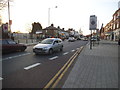
2
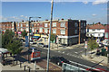
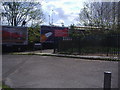
Harrow Road in Sudbury
Looking towards Sudbury & Harrow Road station. This is the terminus for the number 18 bus, evidenced by the three vehicles parked next to the station sign on the other side of the road.
Image: © Martin Addison
Taken: 26 Dec 2011
0.02 miles
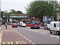
3
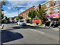
Parade of shops, Harrow Road, Sudbury, northwest London
Old maps show that by 1896 this was mostly farmland; only the south side of Harrow Road (nearest the camera) had a number of properties. By 1914 the Great Central Railway had a station here. By 1935 the whole area was a residential suburb; the railway had become the London and North Eastern Railway. The view is from a London-bound Chiltern train passing Sudbury and Harrow Road station. The side road, right, is Elton Avenue.
Image: © Robin Stott
Taken: 25 Aug 2017
0.02 miles
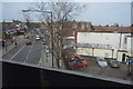
5
Harrow Road, Sudbury
The station of the same name (in reverse order) is on the left.
Image: © David Howard
Taken: 11 Mar 2014
0.03 miles
6
Sudbury Town
Harrow Road
Sudbury Town
Middlesex
Image: © Russell Trebor
Taken: 4 Aug 2006
0.04 miles
8
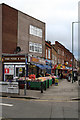
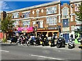
Fruit For Sale, Sudbury
A parade of shops on Harrow Road in Sudbury. The closest is offering bowls of fruit for £1.00p - which is a common practice in many London suburbs.
Image: © Martin Addison
Taken: 26 Dec 2011
0.04 miles
9
Entrance to Sudbury & Harrow Road station
Image: © David Howard
Taken: 23 Apr 2008
0.05 miles
10
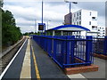
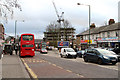
The least used railway station in Greater London
This is Sudbury & Harrow Road station.
On 20th November 1905 the Great Central Railway opened a new route for freight trains between Neasden Junction and Northolt Junction, and on 1st March 1906 passenger services began from High Wycombe to the Great Central's then new terminus at Marylebone. The line was built though open country, yet impressive stations were provided. However, passengers tended to opt for the parallel (now Piccadilly) line, and by 1968 the service was said to be the sparsest in London. Plans were afoot to close it between Neasden and Northolt and direct trains into Paddington, but the line has survived. Despite this it is currently the least used station in Greater London.
This is the view from the up platform. The next train in this direction is Wembley Stadium.
Image: © Marathon
Taken: 15 Jul 2015
0.05 miles