IMAGES TAKEN NEAR TO
Greenbank Avenue, WEMBLEY, HA0 2TF
Introduction
This page details the photographs taken nearby to Greenbank Avenue, HA0 2TF by members of the Geograph project.
The Geograph project started in 2005 with the aim of publishing, organising and preserving representative images for every square kilometre of Great Britain, Ireland and the Isle of Man.

There are currently over 7.5m images from over14,400 individuals and you can help contribute to the project by visiting https://www.geograph.org.uk
Image Map
Images are licensed for reuse under creativecommons.org/licenses/by-sa/2.0
Notes
- Clicking on the map will re-center to the selected point.
- The higher the marker number, the further away the image location is from the centre of the postcode.
Image Listing (34 Images Found)
Images are licensed for reuse under creativecommons.org/licenses/by-sa/2.0
Image
Details
Distance
1
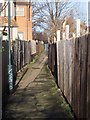
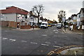
Alleyway - LNER Club
Alleyway behind LNER Club/Maybank Ave (Maybank Open Space)
Image: © Russell Trebor
Taken: 14 Jan 2007
0.07 miles
4
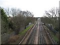
Piccadilly Line in Sudbury (1)
This line to South Harrow was opened in 1903 and extended to Uxbridge in 1910, and was originally operated by the Metropolitan District Railway, responsibility only passing to the Piccadilly Line in 1932. This view was taken from The Rise road bridge looking towards Sudbury Town station. The housing estates came later and an early road map showing the surrounding roads but not the houses shows The Rise as Wembley Avenue. In the distance is one of the distinctive footbridges that cross the line.
Image: © Nigel Cox
Taken: 2 Jan 2010
0.07 miles
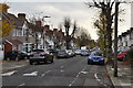
5
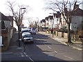
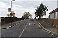
The Rise
Junction with Sudbury Heights Ave
Image: © Russell Trebor
Taken: 14 Jan 2007
0.07 miles