IMAGES TAKEN NEAR TO
Maybank Avenue, WEMBLEY, HA0 2SX
Introduction
This page details the photographs taken nearby to Maybank Avenue, HA0 2SX by members of the Geograph project.
The Geograph project started in 2005 with the aim of publishing, organising and preserving representative images for every square kilometre of Great Britain, Ireland and the Isle of Man.

There are currently over 7.5m images from over14,400 individuals and you can help contribute to the project by visiting https://www.geograph.org.uk
Image Map
Images are licensed for reuse under creativecommons.org/licenses/by-sa/2.0
Notes
- Clicking on the map will re-center to the selected point.
- The higher the marker number, the further away the image location is from the centre of the postcode.
Image Listing (47 Images Found)
Images are licensed for reuse under creativecommons.org/licenses/by-sa/2.0
Image
Details
Distance
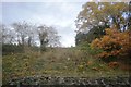
1
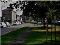
Elms Lane, Sudbury
A green formed by the splayed junction of Elms Lane (in front and right) and Perrin Road (behind the camera).
Image: © Chris Brown
Taken: 9 Sep 2018
0.07 miles
2
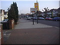
Harrow Road Sudbury
Looking east towards Wembley
Image: © David Howard
Taken: 26 Jan 2010
0.08 miles
3
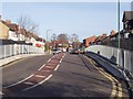
Maybank Avenue
Looking towards Harrow Road (Sudbury)
Image: © Russell Trebor
Taken: 14 Jan 2007
0.09 miles
5
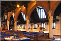
St Andrew, Harrow Road, Sudbury - Arcade
Image: © John Salmon
Taken: 16 Nov 2004
0.12 miles
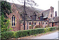
6
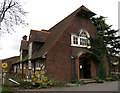
St Andrew, Harrow Road, Sudbury - Old Church
Now the church hall
Image: © John Salmon
Taken: 16 Nov 2004
0.12 miles
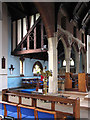
8
St Andrew, Harrow Road, Sudbury - Chapel
Image: © John Salmon
Taken: 16 Nov 2004
0.13 miles
9
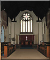
St Andrew, Harrow Road, Sudbury - Chancel
Image: © John Salmon
Taken: 16 Nov 2004
0.13 miles
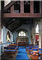
10
St Andrew, Harrow Road, Sudbury - Interior
Image: © John Salmon
Taken: 16 Nov 2004
0.13 miles