IMAGES TAKEN NEAR TO
District Road, WEMBLEY, HA0 2LD
Introduction
This page details the photographs taken nearby to District Road, HA0 2LD by members of the Geograph project.
The Geograph project started in 2005 with the aim of publishing, organising and preserving representative images for every square kilometre of Great Britain, Ireland and the Isle of Man.

There are currently over 7.5m images from over14,400 individuals and you can help contribute to the project by visiting https://www.geograph.org.uk
Image Map
Images are licensed for reuse under creativecommons.org/licenses/by-sa/2.0
Notes
- Clicking on the map will re-center to the selected point.
- The higher the marker number, the further away the image location is from the centre of the postcode.
Image Listing (205 Images Found)
Images are licensed for reuse under creativecommons.org/licenses/by-sa/2.0
Image
Details
Distance
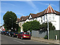
2
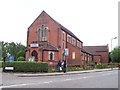
Sudbury Baptist Church
District Road
Image: © Russell Trebor
Taken: 20 Jun 2006
0.02 miles
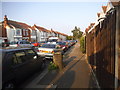
6
Allendale Road, Greenford (2)
The house name plate Image is on the nearest house (right).
Image: © Mike Quinn
Taken: 5 Jul 2017
0.03 miles

8
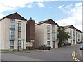
Barham Park Estate, Wembley
This is an estate developed by the local council
Image: © David Hawgood
Taken: 30 Jul 2005
0.04 miles
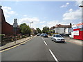
9
Station Approach, Greenford
It's the approach to Image
Image: © Mike Quinn
Taken: 5 Jul 2017
0.04 miles